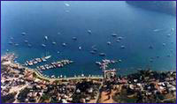
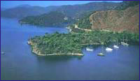
 Gocek Gocek
With its geographical position, Göcek has been transformed over the past several years to become the ‘in’ spot for salty dogs and international yachtsmen, gaining a fine reputation in the process. From the latest model yachts to the smallest boats, the bays of Göcek are one of the few places on earth that mariners can cruise throughout the year. In addition, Göcek is an ideal spot from the standpoint of wind, sea and air temperature, whereas it is located only 22 km. away from Dalaman International Airport. Moreover, its yacht harbor, which was constructed in recent years and is still undergoing expansion. has become a place of distinction. For instance, you can board a plane in Istanbul, or Ankara or from even outside the country and within a couple of hours, you’ll be whisked away from all your outside world worries to embrace Göcek, where the blue sea laps against green forests to form the magical hue of turquoise.
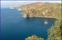 Gulf of Fethiye Gulf of Fethiye
In sailing E from the direction of Marmaris, you will round Kurtoglu Burnu to enter the Gulf of Fethiye, which is one of the most beautiful gulfs in the world. Situated between Kurtoglu Burnu and Iblis Burnu are 12 islands of various sizes and several magnificent bays in this gulf which is swathed in forests. You will never get enough of these bays and they are going to ensure that you have a very delightful time here.
 Aga Limani Aga Limani
When we enter the Fethiye Gulf our next stop will be Aga Limani. From here with a 30-minute hike takes you to ancient Lydae. Off the beaten path and rarely visited, Lydae features sarcophagi, temple walls, cisterns, Corinthian columns and inscribed tablets from the Roman and Byzantine periods.
Gobun Bay
This anchorage, which is surrounded by pine woods and Olive groves, provides shelter from winds in all directions whereby up to 50 vessels can moor here concurrently. If you visit here in the summer, be prepared to put up with the maritime traffic as it is a popular spot.
There is a cozy little bay between Göbün Koyu and Yavansu Koyu, sandwiched between two mountains, called ‘Merdivenli Koyu’ by the local villagers. The small beach inside the steep rocks on either side of the bay is very impressive. The cave situated behind the beach can be reached by climbing over some high steps. It must be because of these steps that the bay was called ‘Merdivenli Koyu.’ 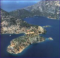 Manastir Bay Manastir Bay
There is a fabulous bay shaded by pines just one nautical mile to the W of Bozburun called Manastir Koyu. In the SE quadrant of Manastir Koyu, one can see ruins in the sea that have been named by the local folks as Cleopatra’s Hamam. However, this is a fallacy as these ruins do not date back to the time of the Egyptian Queen, but rather to that of the Byzantine Empire. The pines lean into the sea as if they are kissing it whereas they stretch from water’s edge to the top of the hills, adding distinct beauty to the bay.
The S quadrant of the bay, where there is an island as well as remnants of a Roman bath, is considered to be an ideal spot to anchor as it remains calm in stormy weather. It is a comfortably nice place to spend the night as long as there is no wind blowing. In the W part of Manastir Koyu is an old, long wall that runs by a restaurant called Wallbay. This wall was built to protect Lydae at the top of the isthmus and its village Arymaxa. From here it extends up to the hill and then back down to the sea again. Thusly, the peninsula was securely cut off from the mainland. When you get to the top of the hill the beautiful view of Gokgemile Koyu is going to amaze you. The shoals off the coast are like a motif of the panoramic view.  Sarsala - Sirali Buk Sarsala - Sirali Buk
Ruins of an old dwelling as well as that of an ancient pier can be seen in the water to the W of the peninsula. There is a road from land to this bay, which is comprised of two coves known as Büyük and Küçük Sarsala.
There are a number of small coves in this bay, which is exposed to the 5, whereas some vessels drop anchor in these coves. There is a mountain path behind these on which one can trek up to Erentepe and Kocagöl. Kocagöl is 2 - 3 km. beyond Sarsala. Here the ancient city of Lyssa is situated at Kizilagaç Mevkii. The only author of antiquity to have ever mentioned this city was Pliny. It is known that the city did not mint any coins but it was mentioned in inscriptions. A part of the acropolis walls remains standing, whereas there are inscriptions on the S side of the walls. These are honor inscriptions that were written in the 3rd century B.C. during the period of Ptolemiac Dynasty. Nothing much remains of the ancient city save for tombs that are seen between the city and the sea. However, as with other cities of antiquity, there most certainly should have been ruins of some private and official buildings as well. honor inscriptions that were written in the 3rd century B.C. during the period of Ptolemiac Dynasty. Nothing much remains of the ancient city save for tombs that are seen between the city and the sea. However, as with other cities of antiquity, there most certainly should have been ruins of some private and official buildings as well. The other name of Sirali Bükü, which is located in the inlet of Martin Burnu to the N of Sarsala Pier, is Martin Koyu. The bay is surrounded by tall mountains and unites with the pine trees growing on the peaks. It is possible to moor anywhere along the cape, which has five beaches.  Bedri Rahmi Cove Bedri Rahmi Cove
One of the most important bays in the gulf is Bedri Rahmi Koyu, known by the local people as Taskaya. Situated opposite Tersane Adasi, this bay was named after the Turkish writer and artist Bedri Rahmi Eyüpoglu, who was one of the first to experience a ‘Blue Voyage’ back in 1973. During this pioneer journey, he painted a picture of a fish on a boulder behind the fountain here. A number of Turkish intellects and artists such as Bedri Rahmi, his brother Selahattin Eyüpoglu and Azra Erhat participated on the first ‘Blue Voyage’ and discovered all this natural beauty. In describing these incredible bays in subsequent newspaper articles and books, they recommended that everyone experience what eventually became known as the ‘Blue Voyage.’
There is a freshwater fountain under some immense pine trees at the NE end of this wide bay, which poses no problems as far as entering it is concerned. You can drop anchor at a depth of 2 —2.5 m. at the spot where a restaurant and a pier are located, and replenish your water supply at the fountain at the same time. You can see Bedri Rahmi’s picture of a fish right behind this fountain and just behind it is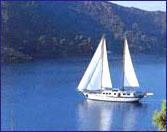 a Lycian rock tomb seemingly lurking amongst the trees. In addition to this tomb, there are numerous Lycian pigeon-hole tombs carved into the face of a [arge rock. In addition, one can encounter a rock tomb with an embroidered gate as well as three tombs lying next to each other further on ahead. These rock tombs are peculiar to the Lycians in that they reflect examples of their wooden edifices. These rock tombs, of which we have seen several examples in Caunos, with more to be seen in Fethiye and Myra, date to the 4th-5th centuries B.C. and belong to the ancient city of Crya, located up on the hill. a Lycian rock tomb seemingly lurking amongst the trees. In addition to this tomb, there are numerous Lycian pigeon-hole tombs carved into the face of a [arge rock. In addition, one can encounter a rock tomb with an embroidered gate as well as three tombs lying next to each other further on ahead. These rock tombs are peculiar to the Lycians in that they reflect examples of their wooden edifices. These rock tombs, of which we have seen several examples in Caunos, with more to be seen in Fethiye and Myra, date to the 4th-5th centuries B.C. and belong to the ancient city of Crya, located up on the hill. 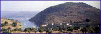 Tersane Island Tersane Island
The largest island in the Gulf of Fethiye is that of Tersane Adasi. One enters Tersane Koyu, which is a natural harbor stretching inland on the island’s NW side, through a deep channel measuring 100 m. across. You can anchor in anywhere in the bay except the E and NE parts, where sunken sections of piers are scattered about in the shallows. It is safer to moor on the W side as it is closed off to the prevailing lodos and yildiz winds.
We know that Tersane Adasi, which used to be known as Telandria, was inhabited during ancient times.However, there are a total of 140 dilapidated houses on land as well as submerged in the sea that catch one’s eye. These houses belonged to the island’s inhabitants who emigrated to Rhodes in 1923. in the sea that catch one’s eye. These houses belonged to the island’s inhabitants who emigrated to Rhodes in 1923. There are ruins of two churches, one adjacent to the well and the other on the hill, as well as the graves of the ancient people’s community leaders in the W. The island derived its name from the fact that the Ottoman naval fleet used it as a shipyard during World War I. Before the population exchange, the people here were known to be involved with raising fruit orchards and animal husbandry. Again, you can still encounter fruit orchards and goat herds. 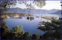 Yassica Isles Yassica Isles
The islands called Yassica Adalari which arouse interest because of their mysterious appearance and are favoured by yachts.
Ak Bükü
 Ak Bükü, which is located N of Boynuz Bükü and W of Göcek Adasi, is comprised of two bays, one situated in the S and the other in the N. There is a large boulder situated in the entrance of the bay, whereas there is a beach and a fountain amidst the pine trees on the N shore. Several bays line the shores between here and Göcek. One of these is Günlüklü Koyu, decorated with styrax trees in the immediate vicinity. Another is Osmanaga Koyu, which is located on the other side of the peninsula which borders Gunlüklü Koyu. However, beware of the small islet S of the bay which renders passage between this islet and the shore impossible. Extending out into the sea like a tongue, Ince Burun Peninsula is situated next to Osmanaga Koyu. Ak Bükü, which is located N of Boynuz Bükü and W of Göcek Adasi, is comprised of two bays, one situated in the S and the other in the N. There is a large boulder situated in the entrance of the bay, whereas there is a beach and a fountain amidst the pine trees on the N shore. Several bays line the shores between here and Göcek. One of these is Günlüklü Koyu, decorated with styrax trees in the immediate vicinity. Another is Osmanaga Koyu, which is located on the other side of the peninsula which borders Gunlüklü Koyu. However, beware of the small islet S of the bay which renders passage between this islet and the shore impossible. Extending out into the sea like a tongue, Ince Burun Peninsula is situated next to Osmanaga Koyu. 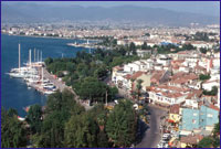 Fethiye Fethiye
Situated on the slopes of Mendos Mountain, Fethiye was established on top of ancient Telmessos on the shores of the Gulf of Fethiye. For this reason, the majority of the ruins have remained under this quaint district. Because of the abundance of accommodation facilities, captivatingly beautiful coves and significant development in yacht tourism in recent years, Fethiye represents the center of excursions in the Lycian region.
The significance of the city, which continued its existence into the Byzantine era, waned with the Arabian raids which occurred after the 7th century. The city’s name was changed to Anastasiupolis during the 8th century in honor of the Byzantine Emperor Anastasiupolis II, whereby the following century this too gave way to the Makri, which meant ‘far city.’ Later on, the city was called Megri, whereas Megri was finally changed to today’s Fethiye in 1934, to commemorate one of the first Turkish aviators, Fethi Bey. C. Texier, who saw Telmessos in the 1850’s, indicated that the Apollo Temple and theater could be 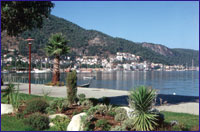 seen at that time. Not long after C.Texier’s visit, a major earthquake struck in 1856, which knocked down these structures, and when Fethiye was hit with a second devastating quake just over 100 years later, in 1957, these ruins were completely destroyed. Today’s Fethiye is what was built up after this second temblor more than forty years ago. Today, the theater, which was found near the pier of new Fethiye, has been uncovered. This theater, which had the capacity to hold 5,000 people, was built in the Early Roman Period and renovated later in the 2nd century A.D. seen at that time. Not long after C.Texier’s visit, a major earthquake struck in 1856, which knocked down these structures, and when Fethiye was hit with a second devastating quake just over 100 years later, in 1957, these ruins were completely destroyed. Today’s Fethiye is what was built up after this second temblor more than forty years ago. Today, the theater, which was found near the pier of new Fethiye, has been uncovered. This theater, which had the capacity to hold 5,000 people, was built in the Early Roman Period and renovated later in the 2nd century A.D. A medieval castle situated on the acropolis hill, where the city was first established, is surrounded by a wall. Today, one can see the bottom portion of this wall, which was erected by the Romans as well as the upper part, which was constructed during the Middle Ages, when the Rhodian Knights used this castle as well as Sövalye Adasi, located in the harbor, to hold the city under their control. 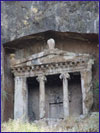 The Tomb of Amyntas, which is the most splendid and best known of all the tombs, is located on the E face of the city’s acropolis and has become the symbol of Fethiye. Seen from the plain below, it gives a great impression of size from up close. It is of the temple-type, in the Ionian order. Four steps lead up to the porch with two columns between pilasters; halfway up the left-hand pilaster the name of Amyntas, son of Hermapias is inscribed in letters of the 4th century B.C. Encountering this tomb in the 1850’s, C. Texier apparently wished to document this as he signed the upper left corner of the grave door. The Tomb of Amyntas, which is the most splendid and best known of all the tombs, is located on the E face of the city’s acropolis and has become the symbol of Fethiye. Seen from the plain below, it gives a great impression of size from up close. It is of the temple-type, in the Ionian order. Four steps lead up to the porch with two columns between pilasters; halfway up the left-hand pilaster the name of Amyntas, son of Hermapias is inscribed in letters of the 4th century B.C. Encountering this tomb in the 1850’s, C. Texier apparently wished to document this as he signed the upper left corner of the grave door.
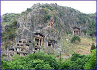 In the cliff-face further to the left are numerous other tombs; two of these are temple-tombs similar to that of Amyntas, and little less impressive. There are also a number of Lycian-type sarcophagi within the city. One of these is situated on the street directly below these stone monuments, while the other stands besides the municipal building near the pier. The sarcophagus next to the municipal building is one of the few sarcophagi with reliefs that has managed to remain intact to the present. Both sides of the lid and of the surmounting Crest carry reliefs showing rows of warriors with shields in their hands, with a man sitting in an armchair wearing long clothing on the right side. The ends of the lid are divided into four panels. This sarcophagus, which was erected in ca. 340 B.C., once had reliefs on the bottom part as well, which is understood from the drawings of both Sir Charles Fellows and C.Texier. In addition, there are two sarcophagi from the 4th Century that are located in the Cumhuriyet District, one of which has reliefs. However, these reliefs are in poor condition. In the cliff-face further to the left are numerous other tombs; two of these are temple-tombs similar to that of Amyntas, and little less impressive. There are also a number of Lycian-type sarcophagi within the city. One of these is situated on the street directly below these stone monuments, while the other stands besides the municipal building near the pier. The sarcophagus next to the municipal building is one of the few sarcophagi with reliefs that has managed to remain intact to the present. Both sides of the lid and of the surmounting Crest carry reliefs showing rows of warriors with shields in their hands, with a man sitting in an armchair wearing long clothing on the right side. The ends of the lid are divided into four panels. This sarcophagus, which was erected in ca. 340 B.C., once had reliefs on the bottom part as well, which is understood from the drawings of both Sir Charles Fellows and C.Texier. In addition, there are two sarcophagi from the 4th Century that are located in the Cumhuriyet District, one of which has reliefs. However, these reliefs are in poor condition.
 Oludeniz Oludeniz
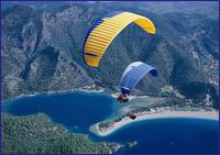
Situated behind Yogan Burnu, Ölü Deniz is a hidden paradise which possesses intriguing beauty. The shadow of the pine trees on the opposite side look as though they being washed in the sea. Vessels have been banned from entering the world-famous Ölü Deniz since 1983. though, it is possible to drop anchor in the inner part of Yogan Burnu, One needs to look out for the rocks in front of this promontory. This tranquil beauty was also discovered by people who lived hundreds of years ago. Christians making their pilgrimage during the 12th century visited Ölü Deniz en route to their destination. In taking shelter here during stormy weather, they prayed and waited for the force of the gale to diminish. In the Medieval Ages. 11 churches for the pilgrim candidates were erected in an area called Sybola. In addition to the churches found on the islands of Karacaören and Gemiler, there is one in the back and another one in the middle part of Ölü Deniz. The church in the middle section is nestled amongst some bushes on the right side of the road leading to Ölü Deniz. The church in the back of Ölü Deniz is situated in the touristic facilities there. Excavation work carried out at one of these church sites indicates that ancient civilizations knew about Ölü Deniz.
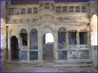
Kayakoy
 It is a Greek settlement founded beginning from 14th century over antic Karmillassos, fully destroyed excluding a few house type tomb as a result of earthquakes and foundation period is not known definitely.Its former name is Levissi. Kayaköy, teaching humanity on the concepts of friendship, brotherhood and peace, and united with five Turkish villages during its lifetime, is one of the pride resources of our region. According to a "population exchange" agreement signed between Turkish and Greek governments on 1922, Greek population of Kayaköy is exchanged with Turkish population residing in Western Thrace. It is a Greek settlement founded beginning from 14th century over antic Karmillassos, fully destroyed excluding a few house type tomb as a result of earthquakes and foundation period is not known definitely.Its former name is Levissi. Kayaköy, teaching humanity on the concepts of friendship, brotherhood and peace, and united with five Turkish villages during its lifetime, is one of the pride resources of our region. According to a "population exchange" agreement signed between Turkish and Greek governments on 1922, Greek population of Kayaköy is exchanged with Turkish population residing in Western Thrace. 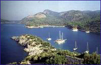 Gemiler Adasi ( St. Nicholas Island ) Gemiler Adasi ( St. Nicholas Island )
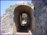
Gemiler Adasi was a town of the Middle Ages. The island, which measures 1,000 x 400 in., is separated from the mainland by a narrow channel in the position of an exquisite harbor. Although the S part of the island is very steep, the N side is very convenient for yachts and because it has a slight grade, it is also possible to get onto the island from here. The N shore was once the island’s harbor, but due to earthquakes which struck the region throughout history, the pier which served the harbor hundreds of years ago remains submerged. We can encounter many ruins on the island. Now, let’s check out the island’s historical edifices starting from the W side. Even as we approach the island, one can see these in all of their magnificence. In addition, there are ruins of a fortification wall on the island. There is a cemetary found on the F side. A number of churches that were constructed on the island were destroyed in the Arab raids of the 7th century. However, the Byzantines regained control of these shores in the ‘12th century and rebuilt these churches, which were located along the route the pilgrims once frequented.
 Some documents written towards the end of the Middle Ages name Gemiler Adasi as ‘St. Nicholas Island.’ Even today, there are some places where the island is referred to as St. Nicholas Island. Though this might be the case, St. Nicholas was born in Patara during the 4th century A.D. and was the archbishop of Myra, so we know he didn’t live on the island. However, there were more than ‘1,000 churches built in Anatolia and beyond that were named after this saint otherwise known as Santa Claus. Some documents written towards the end of the Middle Ages name Gemiler Adasi as ‘St. Nicholas Island.’ Even today, there are some places where the island is referred to as St. Nicholas Island. Though this might be the case, St. Nicholas was born in Patara during the 4th century A.D. and was the archbishop of Myra, so we know he didn’t live on the island. However, there were more than ‘1,000 churches built in Anatolia and beyond that were named after this saint otherwise known as Santa Claus. 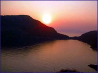 The most magnificent church on Gemiler Adasi is Church No.111, which is located at the highest point on the island, 99 m. above sea level. Books written during the Middle Ages mention this church in the following way, “St. Nicholas Church is located at the top of the island.” This church is a basilica measuring 30 m. long with three passageways. The W portion of the church was made by cutting through the slope of a rock. It is presumed to have had a wooden roof covered with adobe tiles. Access to the entrance is through the mouth of the tunnel which connects this church to Church No.IV. The most magnificent church on Gemiler Adasi is Church No.111, which is located at the highest point on the island, 99 m. above sea level. Books written during the Middle Ages mention this church in the following way, “St. Nicholas Church is located at the top of the island.” This church is a basilica measuring 30 m. long with three passageways. The W portion of the church was made by cutting through the slope of a rock. It is presumed to have had a wooden roof covered with adobe tiles. Access to the entrance is through the mouth of the tunnel which connects this church to Church No.IV.
Reference : "Paradise Preserved" by Ilhan Aksit
|