 Gocek
Gocek
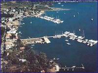
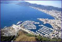
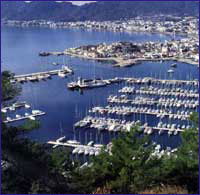
With its geographical position, Göcek has been transformed over the past several years to become the ‘in’ spot for salty dogs and international yachtsmen, gaining a fine reputation in the process. From the latest model yachts to the smallest boats, the bays of Göcek are one of the few places on earth that mariners can cruise throughout the year. In addition, Göcek is an ideal spot from the standpoint of wind, sea and air temperature, whereas it is located only 22 km. away from Dalaman International Airport. Moreover, its yacht harbor, which was constructed in recent years and is still undergoing expansion. has become a place of distinction. For instance, you can board a plane in Istanbul, or Ankara or from even outside the country and within a couple of hours, you’ll be whisked away from all your outside world worries to embrace Göcek, where the blue sea laps against green forests to form the magical hue of turquoise.
 Gulf of Fethiye
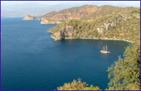
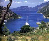
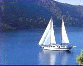
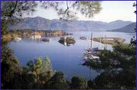
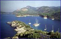
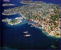
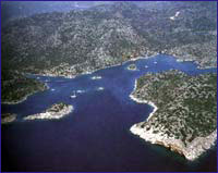
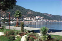
In sailing E from the direction of Marmaris, you will round Kurtoglu Burnu to enter the Gulf of Fethiye, which is one of the most beautiful gulfs in the world. Situated between Kurtoglu Burnu and Iblis Burnu are 12 islands of various sizes and several magnificent bays in this gulf which is swathed in forests. You will never get enough of these bays and they are going to ensure that you have a very delightful time here.
 Aga Limani
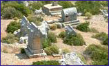
When we enter the Fethiye Gulf our next stop will be Aga Limani. From here with a 30-minute hike takes you to ancient Lydae. Off the beaten path and rarely visited, Lydae features sarcophagi, temple walls, cisterns, Corinthian columns and inscribed tablets from the Roman and Byzantine periods.
Gobun Bay
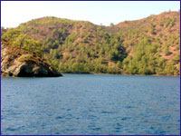
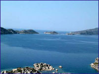
This anchorage, which is surrounded by pine woods and Olive groves, provides shelter from winds in all directions whereby up to 50 vessels can moor here concurrently. If you visit here in the summer, be prepared to put up with the maritime traffic as it is a popular spot.
There is a cozy little bay between Göbün Koyu and Yavansu Koyu, sandwiched between two mountains, called ‘Merdivenli Koyu’ by the local villagers. The small beach inside the steep rocks on either side of the bay is very impressive. The cave situated behind the beach can be reached by climbing over some high steps. It must be because of these steps that the bay was called ‘Merdivenli Koyu.’
 Manastir Bay
There is a fabulous bay shaded by pines just one nautical mile to the W of Bozburun called Manastir Koyu. In the SE quadrant of Manastir Koyu, one can see ruins in the sea that have been named by the local folks as Cleopatra’s Hamam. However, this is a fallacy as these ruins do not date back to the time of the Egyptian Queen, but rather to that of the Byzantine Empire. The pines lean into the sea as if they are kissing it whereas they stretch from water’s edge to the top of the hills, adding distinct beauty to the bay.
The S quadrant of the bay, where there is an island as well as remnants of a Roman bath, is considered to be an ideal spot to anchor as it remains calm in stormy weather. It is a comfortably nice place to spend the night as long as there is no wind blowing.
In the W part of Manastir Koyu is an old, long wall that runs by a restaurant called Wallbay. This wall was built to protect Lydae at the top of the isthmus and its village Arymaxa. From here it extends up to the hill and then back down to the sea again. Thusly, the peninsula was securely cut off from the mainland.
When you get to the top of the hill the beautiful view of Gokgemile Koyu is going to amaze you. The shoals off the coast are like a motif of the panoramic view.
 Sarsala - Sirali Buk
Ruins of an old dwelling as well as that of an ancient pier can be seen in the water to the W of the peninsula. There is a road from land to this bay, which is comprised of two coves known as Büyük and Küçük Sarsala.
There are a number of small coves in this bay, which is exposed to the 5, whereas some vessels drop anchor in these coves. There is a mountain path behind these on which one can trek up to Erentepe and Kocagöl.
Kocagöl is 2 - 3 km. beyond Sarsala. Here the ancient city of Lyssa is situated at Kizilagaç Mevkii. The only author of antiquity to have ever mentioned this city was Pliny. It is known that the city did not mint any coins but it was mentioned in inscriptions. A part of the acropolis walls remains standing, whereas there are inscriptions on the S side of the walls. These are honor inscriptions that were written in the 3rd century B.C. during the period of Ptolemiac Dynasty. Nothing much remains of the ancient city save for tombs that are seen between the city and the sea. However, as with other cities of antiquity, there most certainly should have been ruins of some private and official buildings as well.
The other name of Sirali Bükü, which is located in the inlet of Martin Burnu to the N of Sarsala Pier, is Martin Koyu. The bay is surrounded by tall mountains and unites with the pine trees growing on the peaks. It is possible to moor anywhere along the cape, which has five beaches.
 Bedri Rahmi Cove
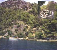
One of the most important bays in the gulf is Bedri Rahmi Koyu, known by the local people as Taskaya. Situated opposite Tersane Adasi, this bay was named after the Turkish writer and artist Bedri Rahmi Eyüpoglu, who was one of the first to experience a ‘Blue Voyage’ back in 1973. During this pioneer journey, he painted a picture of a fish on a boulder behind the fountain here. A number of Turkish intellects and artists such as Bedri Rahmi, his brother Selahattin Eyüpoglu and Azra Erhat participated on the first ‘Blue Voyage’ and discovered all this natural beauty. In describing these incredible bays in subsequent newspaper articles and books, they recommended that everyone experience what eventually became known as the ‘Blue Voyage.’
 There is a freshwater fountain under some immense pine trees at the NE end of this wide bay, which poses no problems as far as entering it is concerned. You can drop anchor at a depth of 2 —2.5 m. at the spot where a restaurant and a pier are located, and replenish your water supply at the fountain at the same time. You can see Bedri Rahmi’s picture of a fish right behind this fountain and just behind it is a Lycian rock tomb seemingly lurking amongst the trees. In addition to this tomb, there are numerous Lycian pigeon-hole tombs carved into the face of a [arge rock. In addition, one can encounter a rock tomb with an embroidered gate as well as three tombs lying next to each other further on ahead. These rock tombs are peculiar to the Lycians in that they reflect examples of their wooden edifices. These rock tombs, of which we have seen several examples in Caunos, with more to be seen in Fethiye and Myra, date to the 4th-5th centuries B.C. and belong to the ancient city of Crya, located up on the hill.
 Tersane Island
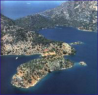
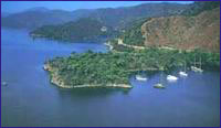
The largest island in the Gulf of Fethiye is that of Tersane Adasi. One enters Tersane Koyu, which is a natural harbor stretching inland on the island’s NW side, through a deep channel measuring 100 m. across. You can anchor in anywhere in the bay except the E and NE parts, where sunken sections of piers are scattered about in the shallows. It is safer to moor on the W side as it is closed off to the prevailing lodos and yildiz winds.
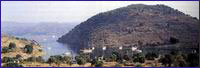
We know that Tersane Adasi, which used to be known as Telandria, was inhabited during ancient times.However, there are a total of 140 dilapidated houses on land as well as submerged in the sea that catch one’s eye. These houses belonged to the island’s inhabitants who emigrated to Rhodes in 1923.
 There are ruins of two churches, one adjacent to the well and the other on the hill, as well as the graves of the ancient people’s community leaders in the W.
The island derived its name from the fact that the Ottoman naval fleet used it as a shipyard during World War I. Before the population exchange, the people here were known to be involved with raising fruit orchards and animal husbandry. Again, you can still encounter fruit orchards and goat herds.
 Yassica Isles
The islands called Yassica Adalari which arouse interest because of their mysterious appearance and are favoured by yachts.
Ak Bükü
 Ak Bükü, which is located N of Boynuz Bükü and W of Göcek Adasi, is comprised of two bays, one situated in the S and the other in the N. There is a large boulder situated in the entrance of the bay, whereas there is a beach and a fountain amidst the pine trees on the N shore. Several bays line the shores between here and Göcek. One of these is Günlüklü Koyu, decorated with styrax trees in the immediate vicinity. Another is Osmanaga Koyu, which is located on the other side of the peninsula which borders Gunlüklü Koyu. However, beware of the small islet S of the bay which renders passage between this islet and the shore impossible. Extending out into the sea like a tongue, Ince Burun Peninsula is situated next to Osmanaga Koyu.
 Oludeniz
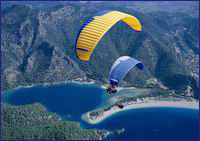
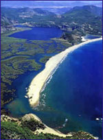
Situated behind Yogan Burnu, Ölü Deniz is a hidden paradise which possesses intriguing beauty. The shadow of the pine trees on the opposite side look as though they being washed in the sea. Vessels have been banned from entering the world-famous Ölü Deniz since 1983. though, it is possible to drop anchor in the inner part of Yogan Burnu, One needs to look out for the rocks in front of this promontory. This tranquil beauty was also discovered by people who lived hundreds of years ago. Christians making their pilgrimage during the 12th century visited Ölü Deniz en route to their destination. In taking shelter here during stormy weather, they prayed and waited for the force of the gale to diminish. In the Medieval Ages. 11 churches for the pilgrim candidates were erected in an area called Sybola. In addition to the churches found on the islands of Karacaören and Gemiler, there is one in the back and another one in the middle part of Ölü Deniz. The church in the middle section is nestled amongst some bushes on the right side of the road leading to Ölü Deniz. The church in the back of Ölü Deniz is situated in the touristic facilities there. Excavation work carried out at one of these church sites indicates that ancient civilizations knew about Ölü Deniz.
 Gemiler Adasi ( St. Nicholas Island )
Gemiler Adasi was a town of the Middle Ages. The island, which measures 1,000 x 400 in., is separated from the mainland by a narrow channel in the position of an exquisite harbor. Although the S part of the island is very steep, the N side is very convenient for yachts and because it has a slight grade, it is also possible to get onto the island from here. The N shore was once the island’s harbor, but due to earthquakes which struck the region throughout history, the pier which served the harbor hundreds of years ago remains submerged. We can encounter many ruins on the island. Now, let’s check out the island’s historical edifices starting from the W side. Even as we approach the island, one can see these in all of their magnificence. In addition, there are ruins of a fortification wall on the island. There is a cemetary found on the F side. A number of churches that were constructed on the island were destroyed in the Arab raids of the 7th century. However, the Byzantines regained control of these shores in the ‘12th century and rebuilt these churches, which were located along the route the pilgrims once frequented.
 Some documents written towards the end of the Middle Ages name Gemiler Adasi as ‘St. Nicholas Island.’ Even today, there are some places where the island is referred to as St. Nicholas Island. Though this might be the case, St. Nicholas was born in Patara during the 4th century A.D. and was the archbishop of Myra, so we know he didn’t live on the island. However, there were more than ‘1,000 churches built in Anatolia and beyond that were named after this saint otherwise known as Santa Claus.
 The most magnificent church on Gemiler Adasi is Church No.111, which is located at the highest point on the island, 99 m. above sea level. Books written during the Middle Ages mention this church in the following way, “St. Nicholas Church is located at the top of the island.” This church is a basilica measuring 30 m. long with three passageways. The W portion of the church was made by cutting through the slope of a rock. It is presumed to have had a wooden roof covered with adobe tiles. Access to the entrance is through the mouth of the tunnel which connects this church to Church No.IV.
Yesilköy - Kalkan
 After spending enough time wandering about Karacaören Adalari, Gemiler Adasi, Bektas Limani and Ölü Deniz, it’s time to set sail towards Kalkan. In manuevering around Kötü Burun and Yedi Burun, and making a cautious transit around the reef situated two nautical miles SE of Ince Burnu, you shall arrive in front of Patara. However, because the sea is constantly in motion, it is not wise to stop here for any length of time. So, let’s just look at Patara’s wide beach from the yacht and continue on our way. We reach Kalkan by navigating between Yali Burnu and Çatal Adalari. The yacht harbor and breakwater in Kalkan, which is exposed to the NW wind, is a secure shelter for yachts. The harbor has been completely renovated in recent years and is able to meet all your yachting needs. Before the founding of the Turkish Republic, Kalkan was known as Kalamiki and it was an old Greek village.
Today, it has been transformed into a spot which is preferred by numerous people with its clean pensions, and restaurants serving up fresh fish and appetizers. You can also take daily sidetrips from Kalkan to visit the ruins of ancient Lycian cities in the vicinity, such as Patara, Letoon and Xanthos. In addition, Yesilköy Limani, which is just opposite Kalkan, is a decent place to drop anchor.
 Kas
Kas
Kas is another place where you can moor safely overnight after departing Kalkan. The marina there is protected by a breakwater against the winds blowing from the W and SW and at the end of the harbor there is a lighthouse. Entry into the harbor must be made carefully because of the rocks in front of lnce Burun where the lighthouse stands. The space in front of the rocky beach at the SE end of the harbor is the best bet for mooring, though you should not manuever too closely to shore as there is a shallow and rocky 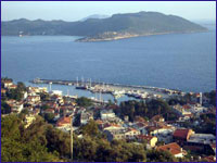 sandbank.
The marina provides water, fuel, electrical current and garbage disposal services whereas you can stock up on provisions in town. Meals served in the restaurants are delicious and leave you with pleasant memories. As Ka~ is an administrative district, you will find services such as a PTT, pharmacies, dentist offices and dispensaries as well.
 Kekova
Kekova, where history and nature are entwined, shelters incredible beauties. An easily accessible place where ‘Blue Voyagers’ can feel confident about dropping anchor, Kekova exhibits unbelievable beauty that is an inseparable part of history.After departing Kas, you will sail past Uluburun and set a course for Kekova, a spot that is practically paradise. One first encounters Siçak Peninsula, where the ancient city of Aperlae is found. At the end of this peninsula are two islands, Toprak and Kara.
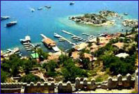
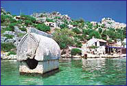
 Kekova Adasi stretches out from here and it is because of this island that the surrounding region is called Kekova. It is also called ‘Sunken City’ as the historical buildings on Kekova Adasi sank in the water as a result of various earthquakes. Passing between the islands and arriving at Kekova, the safest place to anchor is off the village of Uçagiz, which is a decent all-round harbor.
 This is an area where history mingles with nature and today’s lifestyle. There are a number of ancient cities situated very close to each to other here, such as Aperlae on the Sicak Quay, Simena, in the sunken city of Kaleköy, Theimussa, which is found on Ucagiz, and Istlada, which sits above Gökkaya Koyu. In addition to these cities along the coast, there is also Apollonia in Kiliçli, as well as the ancient city of Tyberissos, in Çevreli on the road two km. outside Uçagiz. Tyberissos towers 365 m. above sea level on a hill overlooking the plain of Tirmisin. At the foot of the mountain, and a little above the level of the plain, is an attractive glade in which are a dozen or so Lycian sarcophagi and a number of pigeon-hole tombs. By their inscriptions, they date back to Hellenistic and Roman times.
Kaleköy
 Here, a modern village is interspersed with edifices remaining from antiquity. Paying close attention to the islets in front, you can manuever to a point in front of Kaleköy, where the ruins of the ancient city of Simena are found. You can tie a mooring rope around one of the jetties here which belong to the restaurants. However, take heed of the sunken pier in front of these restaurants. Because it is exposed to the SW winds, it does not offer much shelter, so it is not a good idea to stay moored very long.
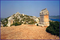
Kaleköy has an intriguing appearance in that there is a medieval castle at the top of the hill, modern structures down below the castle, with ruins of a baths and Lycian monument tombs situated in between.
 The Lyican region’s smallest theater, which was carved out of the rocks, is found inside the medieval castle. From here, you won’t get enough of the view of Ucagiz and Gökkaya Koyu. You will encounter several sarcophagi scattered around the castle which date from the Hellenistic and Roman Periods. Some of these are visible in the sea along with remnants of the ancient harbor and piers.
We are going to provide you with more details of this place, where the ruins of the ancient city of Simena are found, Aperlae, which is located in Sicak Iskelesi, as well as Theimussa, which is located in Ucagiz, in our chapter entitled ‘Kekova,’ where you’ll be able to follow the history of these ancient cities as well as acquire information about the historical structures you encounter.
 Ucagiz
Üçagiz is the sole spot that connects Kekova to the mainland. This is one of the most sheltered places on Kekova, whereas the village of Uca~iz is located on the N shore of this bay, which is surrounded by green hills. Due to the islands positioned in front, entering the bay is a bit difficult. For this, you will need to navigate past the W shores of the islands on the E. This is a clean passage, however, there are submerged shoals along the shores of the islands to the W. You can also manuever by either side of the rocky island in the middle and anchor anywhere you want in the bay to a depth of 5-10 m. It is possible to see the ruins of the ancient city of Theimussa right on the shores of Ücagiz.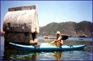
The Lycian tomb found amongst these ruins is significant in that is has an inscription written on it. One can see sarcophagi belonging to the Hellenistic and Roman Periods right next to the restaurants on the seashore. You can moor alongside one of the jetties situated in front of the restaurants in Ücagiz and check out the historical edifices on the shore after dining in one of these restaurants
 Gökkaya
Situated right next door to Kekova, Gökkaya Koyu possesses awe-inspiring beauty with the indented shores of several islands positioned in front. Vessels can find a spot to anchor practically anywhere in the bay. In front of Gökkaya Koyu are the islands of Asirli and Kisneli whereby there is a smaller island between these known as Kasirli. There are smaller islets spread around inside the bay. Sailing into Gökkaya Limani from Kekova, you can enter by manuevering between Kisneli Ada and the mainland and through the deep channels between Asirli Ada and Kisneli Ada. However, you will need to pay close attention to the Martini Reef to the S of Kisneli Ada. The water is clear in Gökkaya, which is an ideal anchorage as it is closed to all winds. Because the freshwater which flows off the mountains stays on top of the salty seawater, the upper layer of the water is cold while the lower layer is warm. This will come as a brisk surprise for those who want to take a refreshing dip in the water during the summer.
There is a restaurant in the bay that serves the vessels at anchor, whereas they also have a disco that you can check out at night. You can see a church apse behind Gökkaya Koyu. Adjacent to this, if you follow along the goat herders’ track to the E quadrant of the hill, you will come to the site of the ancient city of lstlada.
 Demre ( Myra - St. Nicholas )
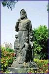
Myra retained her fame throughout the Middle Ages as the see of the servant of God, St. Nicholas, who spouted forth myrrh, in accordance with the city’s name. Myra was established on the seaward cliffs of the mountains surrounding the plain of Demre from the NW. At first, the city was established on top of the hill where the rock tombs are situated, then later on, it expanded by moving down below where it became one of the six important cities of Lycia. The city’s first coins, which were minted in the 4th century B.C., depicted the figure of a mother god.
Ekincik
 cape of Ekincik Koyu and surrounded by green pine woods. Just as you are able to anchor in several spots in the wide Ekincik Koyu, a bay called “My Marina” is also a secure anchorage. Here the local people have formed an pleasant motorboat taxi service that takes you from your yacht on up to Caunos. You can drop anchor in the part the motorboats are located, in front of the wide beach, or else you can even in the nearby bay just opposite the lighthouse.
If by any chance you can find a place for you and your mates in this bay of blues and greens, anchoring here is going to be both secure and enjoyable.
 Those daily excursion motorboats out of Marmaris only go as far as Delik Adasi, where the Dalyan Stream flows into the sea. From here you’ll board another motorboat that takes you to Caunos along a very shallow channel that resembles a dreamworld.
The channel, which twists and winds its way all the way up to Köycegiz Gölü, takes on another meaning with magnificent scenery of the reedy marshes and Lycian rock tombs. After wandering around the Caunos ruins and visiting the curative mud baths, the romantic return to the sea is bound to remain etched in your memories for the rest of your lives.
 Dalyan / Caunos (optional trip to Dalyan - mud baths, turtlesand ruins of Caunos)
Situated on the border of ancient Lycia and Caria, Caunos receives much attention today for the fact that it is very close to where the giant loggerhead turtle Caretta Caretta goes ashore to deposit its eggs, for its Lyciantype tombs, for its Venetian-like channel and most importantly for its ruins.
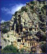
As the taxi boat winds its way through the channel up to Caunos, you will suddenly come face to face with several magnificent Lycian-type rock tombs. There are three stone beds inside the tombs in which the deceased were placed. From the fragments of earthenware uncovered, the tombs have been dated to the 4th century B.C. One of the three of four inscriptions that were found just above these tombs, contains two words related to the Carian language, while it is understood that the other tombs were recycled during the Roman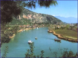 Period. The facades of the tombs, which were carved out of the sheer rock have two columns of the Ionian order. On top of the columns, you’ll see exterior friezes above pediments which were decorated with acroters in three corners. Most of the columns are no longer intact. Of the pediments, all but one is plain, with a unique example of a relief of two lions positioned face-to-face. To the side of this incredible group of tombs is yet another tomb, which is plainer, and incomplete. On the W end of this group of tombs, which is near the village, are more Carian-type tombs which were not decorated like the others. In addition, there are niches that were opened on the lower rock surface for votive offerings.
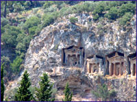
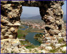
The name Dalyan’ means fishery, and a complicated system of barriers has been built among the reeds to allow the gray mullet and sea bass to be caught as they head for the sea. Let’s go ashore at the landing next to the fishery and wander around the ruins. The first thing we see is the acropolis of Caunos, which rises 152 m. high over a cliff in the S quadrant. The fortification walls situated in the N quadrant appear to be from the Middle Ages.
 This trip will be absolutely your favorite because it offers you such variety. Experience beautiful scenery while cruisig through the Dalyan river marshes. Passing the famous Caunos rock tombs and ruins before arriving the mud baths. Here you have a chance to pamper yourself in the mud and sulphur pools and will feel the wrinkles dissaoearing! Now feeling cleansed and fresh you are ready for a riverside lunch stop and perhaps a beer or two! After lunch drift down the river again to relax, soak up the sun, swim and share the same beach space as the Caretta Caretta turtles who still breed here.
 Marmaris
As this quaint district, which is surrounded by green pine forests, was established directly over the ancient city of Phychos we do not have much information about the ancient site. However, from what we gather from a certain inscription, Phychos existed during the time of Alexander the Great, whereby the acropolis of this city was established one kilometer N of Marmaris on a low hill called Asartepe. Though it wasn’t long ago when there were visible remains of the ancient fortification wall, which was erected in the Classic and Hellenistic Periods, nothing can be seen of it today. After the death of Alexander, the Marmaris region was annexed to the Pergamon Kingdom, then it was captured by the Romans, Byzantines, the Mentese Beylik and then the Ottomans, respectively.
Among the few historical buildings found in Marmaris today, are a castle, which was built in 1557 and recently restored, a mosque in Kemeralti District, which was built by Mengelizade Ibrahim Aga in 1789 as well as a caravanserai which was constructed in 1545. This stone inn with brick vaults was erected on the road to Mugla during the reign of Süleyman the Magnificent in the military campaign against Rhodes. Located near the old junior high school is the Degirmen Brook Bridge, which was also erected during the time of Süleyman the Magnificent.
 If you have the time, we recommend that you check out Sedir Adasi, as well as Karacasögüt, where you can see ancient theaters, temples and fortification walls. As you come out the bay, your boat will manuever past Keci Adasi and Yildiz Adasi, otherwise known as Nimara to call on Alkaya Cave. Then you will sail out to Kumlubük where to take a break of a couple of hours for lunch and an afternoon swim in the sea. Straight up from the pier are the Amos Ruins, which are situated on Asartepe.
With its styrax forest in the middle of the city, excursion trips taken with motorboats and its natural beauty, Marmaris is an ideal spot for rest and relaxation. In addition, the town, which is complimented with wonderful nearby bays such as Sedir Adasi, Karacasögüt, Mersincik, Hisarönü, is a paradise on earth.
 Fethiye
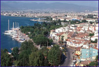
Situated on the slopes of Mendos Mountain, Fethiye was established on top of ancient Telmessos on the shores of the Gulf of Fethiye. For this reason, the majority of the ruins have remained under this quaint district. Because of the abundance of accommodation facilities, captivatingly beautiful coves and significant development in yacht tourism in recent years, Fethiye represents the center of excursions in the Lycian region.
The significance of the city, which continued its existence into the Byzantine era, waned with the Arabian raids which occurred after the 7th century. The city’s name was changed to Anastasiupolis during the 8th century in honor of the Byzantine Emperor Anastasiupolis II, whereby the following century this too gave way to the Makri, which meant ‘far city.’ Later on, the city was called Megri, whereas Megri was finally changed to today’s Fethiye in 1934, to commemorate one of the first Turkish aviators, Fethi Bey.
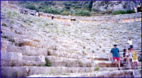
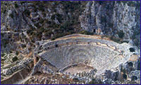
 C. Texier, who saw Telmessos in the 1850’s, indicated that the Apollo Temple and theater could be seen at that time. Not long after C.Texier’s visit, a major earthquake struck in 1856, which knocked down these structures, and when Fethiye was hit with a second devastating quake just over 100 years later, in 1957, these ruins were completely destroyed. Today’s Fethiye is what was built up after this second temblor more than forty years ago. Today, the theater, which was found near the pier of new Fethiye, has been uncovered. This theater, which had the capacity to hold 5,000 people, was built in the Early Roman Period and renovated later in the 2nd century A.D.
A medieval castle situated on the acropolis hill, where the city was first established, is surrounded by a wall. Today, one can see the bottom portion of this wall, which was erected by the Romans as well as the upper part, which was constructed during the Middle Ages, when the Rhodian Knights used this castle as well as Sövalye Adasi, located in the harbor, to hold the city under their control.
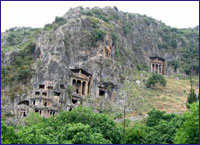
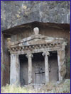 The Tomb of Amyntas, which is the most splendid and best known of all the tombs, is located on the E face of the city’s acropolis and has become the symbol of Fethiye. Seen from the plain below, it gives a great impression of size from up close. It is of the temple-type, in the Ionian order. Four steps lead up to the porch with two columns between pilasters; halfway up the left-hand pilaster the name of Amyntas, son of Hermapias is inscribed in letters of the 4th century B.C. Encountering this tomb in the 1850’s, C. Texier apparently wished to document this as he signed the upper left corner of the grave door.
 In the cliff-face further to the left are numerous other tombs; two of these are temple-tombs similar to that of Amyntas, and little less impressive. There are also a number of Lycian-type sarcophagi within the city. One of these is situated on the street directly below these stone monuments, while the other stands besides the municipal building near the pier. The sarcophagus next to the municipal building is one of the few sarcophagi with reliefs that has managed to remain intact to the present. Both sides of the lid and of the surmounting Crest carry reliefs showing rows of warriors with shields in their hands, with a man sitting in an armchair wearing long clothing on the right side. The ends of the lid are divided into four panels. This sarcophagus, which was erected in ca. 340 B.C., once had reliefs on the bottom part as well, which is understood from the drawings of both Sir Charles Fellows and C.Texier. In addition, there are two sarcophagi from the 4th C