 Bodrum Bodrum
Bodrum, the native homeland of the famous historian Herodotus, is one of Turkey’s most important tourism centers, which attracts attention by virtue of its natural beauty.
We know that the native inhabitants, namely the Lelegians and the Carians, lived in the hills above the Bodrum Peninsula. In fact, although there are very few remnants extant, it has been determined that a number of Lelegian cities such as Termera, Pedesa, Thangela, Syengela, Myndos and Telmissus existed above the peninsula. In the Iliad, Homer tells us that the Lelegians, who were under the command of Altes, as well as the Carians, under the command of Nartes fought on the side of the Trojans during the Trojan Wars of ca. 1200 B.C.  After the Turks entered Anatolia in 1071, they ater began establishing provinces in the regions they had settled. As a matter of fact, the Turks under command of Mentese Beytook over this region and the established the Mentese Province in 1274. This area was put under Ottoman rule once and for all during the reign of Sultan Suleyman the Magnificent After the Turks entered Anatolia in 1071, they ater began establishing provinces in the regions they had settled. As a matter of fact, the Turks under command of Mentese Beytook over this region and the established the Mentese Province in 1274. This area was put under Ottoman rule once and for all during the reign of Sultan Suleyman the Magnificent
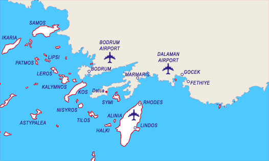
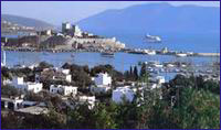
Not much remains to this day of Halicarnassos as it is buried under the modern town of Bodrum. The theater on the hill belongs to the Mausolos period. Excavation and restoration work of the theater has been carried out, whereby 30 rows of seating in the lower section were brought to light. On the S slope of the theater, the upper section of which is heavily damaged, you can encounter rock tombs belonging to the Hellenistic and Roman Periods. Ancient sources reveal that 1) the Temple of Mars and the stoa of Apollo are under the road in front of the theater. 2) the Temples of Hermes and Aphrodite were situated on both sides of Kaplankale, across from the castle and 3) there was the palace of King Mausolos where the mosque is located, in the square in front of the castle. Today, the Myndos Gate, which was a portion of the wall that once surrounded the city, can be seen on the road to Gumbet The castle, which has become the symbol of modern day Bodrum, was built by the Knights of Rhodes in the year 1402. It measures 180 x 185 m. and its first battlements were erected by German architect Heinrich Schlegolholt. Later on, the castle was reinforced with the Italian, French, English, German Towers as well as the Snake Tower. There are a total of 249 coat-of-arms found throughout the castle walls. The Turks captured it in 1 523, whereas today, it serves as the Bodrum Museum of Underwater Archaeology. In the adjacent garden, you are bound to encounter numerous peacocks which seemingly stand guard over the treasures, not terribly unlike their Beefeater counterparts at the Tower in London.  There are not many Turkish edifices in Bodrum. The famous Bodrum boats or gulet as they are known in Turkish were constructed during the Ottoman Period in a shipyard just beyond the yacht marina. Today, the manufacture of these fine wooden vessels continues in this area. There is the tomb of Kaptan-i Derya Kizilhisarli Mustafa Pasha and his son Cafer Pasha situated where this shipyard is located. There is also the mosque in the quay square that was built by Mustafa Pasha in 1720. The Pasha’s steward also had the Tepecik Mosque built. Erected in 1769, the Haci Molla Inn survives to this day. but not in its original fashion. There are not many Turkish edifices in Bodrum. The famous Bodrum boats or gulet as they are known in Turkish were constructed during the Ottoman Period in a shipyard just beyond the yacht marina. Today, the manufacture of these fine wooden vessels continues in this area. There is the tomb of Kaptan-i Derya Kizilhisarli Mustafa Pasha and his son Cafer Pasha situated where this shipyard is located. There is also the mosque in the quay square that was built by Mustafa Pasha in 1720. The Pasha’s steward also had the Tepecik Mosque built. Erected in 1769, the Haci Molla Inn survives to this day. but not in its original fashion.
Bodrum is one of the traditional points of embarkment for Blue Voyagers whereas its many bars, cafes, clubs and restaurants offer countless opportunities for fun until the crack of dawn. There are several sites of ruins around the Bodrum Peninsula. For example, you may visit the ancient city of Heracleia, which was established on top of a hill overlooking Bafa Gölü. There you will see the Temple of Athena, which was erected during the Hellenistic Age. Also, 12 km. outside of Milas, on the side of the road, you will encounter the Temple of Euromos Zeus with its 6 x 11 colonnade. It was erected during the Roman Age. Also, the Labranda Ruins, which are 13 km. outside Milas, are quite impressive as well. In addition, Iasos, which is situated in the village of Kiyikislacik is worth a visit. 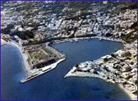 Kos Kos
Home of the Hippocrates, the father of medicine, which is a large island full of contrasts. Rich in history, with many ancient ruins, as well as modern, lively towns, Kos is most enjoyable. Apart from the main, busy harbour, you can also visit Kamares, a more secluded cove.
Kardemena – This harbor lies on the SE coast of the island. It used to be a small fishing village but now has become a resort area. It provides good shelter from the meltemi, there is a pier to moor on to but at night due to the nightlife it can get a bit 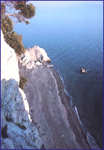 noisy. Fuel, water and provisioning are available. noisy. Fuel, water and provisioning are available. Limin Kos - A fairly busy harbor as there are small boats that go back and forth from Turkey. During the meltemi it offers good shelter but it does tend to swell up. All facilities are available. Masthari – This is a small fishing village on the NW coast of Kos. There is a new mole and offers good shelter from the meltemi. Ormos Kamares – This small bay is located on the South end of the island. It offers good shelter from the meltemi and there is a small mole to moor on to. Water is also available at the mole as well as few tavernas. 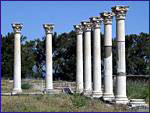 
 Nisiros Nisiros
An extinct volcanic crater. The island itself is almost square . The soil is very rich therefor the island is rich in vegetation. Take a walk up to the crater which spans 2 ½ miles across. The view is spectacular.
Mandraki – The main harbor of Nisiros there is mole and quay to tie onto. During high meltemi winds the harbor can become uncomfortable and even dangerous. Provisioning is available and several tavernas. Palon - This harbor lies 2 miles E of Mandraki. There is a mole to tie on and it offers good shelter form the meltemi. Make sure to eat some fresh fish at one of the many tavernas. There is also a mini market for provisioning. Tilos
 The small island which is situated between Nisiros and Khalki is not visited by many tourists. During medieval the island was used to signal the island of Rhodes of approaching enemies. The small island which is situated between Nisiros and Khalki is not visited by many tourists. During medieval the island was used to signal the island of Rhodes of approaching enemies. Tilos has been one of the best-kept secrets in the Dodecanese for some time, with good unspoiled beaches, friendly people and wonderful walking country: a tranquil antidote to Kos town. From a distance it looks arid but it shelters groves of figs, almonds, walnuts, pomegranates and olives, all watered by fresh springs. Ormos Livadhi – Located on the East coast of Tilos the large bay has a small quay. During the meltemi there can be a swell into the bay. Water and provisioning are available and there are number of tavernas. 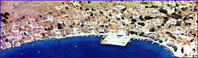 Halki Halki
Halki is one of the smallest islands in the Dodecanese. It is a mountainous, rocky island with excellent shores and numerous caves. Its stone houses are built amphitheatrically on mount Maistros (593 m), the island's highest peak. Its climate is very healthy, as it is mild both in winter and in summer. The winds can be very strong 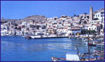 sometimes though and the sea can get stormy. It has a population of about 350 inhabitants, which are mostly stock-breeders and fishermen. Halki produces various stock-breeding products and fresh fish catches are served in every taverna. The inhabitants are simple, jolly, and warm-hearted people. In recent years, the island has been proclaimed an international meeting centre for young people. A municipal guest house has been built for this purpose. The locals approve of this movement and contribute the best they can to its preservation and further development. sometimes though and the sea can get stormy. It has a population of about 350 inhabitants, which are mostly stock-breeders and fishermen. Halki produces various stock-breeding products and fresh fish catches are served in every taverna. The inhabitants are simple, jolly, and warm-hearted people. In recent years, the island has been proclaimed an international meeting centre for young people. A municipal guest house has been built for this purpose. The locals approve of this movement and contribute the best they can to its preservation and further development.
Bozukkale
 Bozukkale Harbor maintained its importance throughout the Byzantine Period as a Byzantine naval base and armory, whereas warship maintenance was carried out in this shipyard. Bozukkale Harbor maintained its importance throughout the Byzantine Period as a Byzantine naval base and armory, whereas warship maintenance was carried out in this shipyard. After anchoring in this historical bay, let’s climb up to see the castle situated at the end of the cape. Measuring 27.4 m. wide by 320 m. long, and surrounded by fortification walls 2.44 in. in thickness, this long, narrow castle was erected to protect the bay. There were once nine square-shaped ramparts along protective walls made from straight cut stones. However of the original nine, only a single promontory rampart in the N can be seen today. There are round towers situated at the two ends of the castle. Immediately in front of these towers are cisterns which were carved partly from the rock. Four of the five gates of the fortification wall are situated in the section facing N. The ancient city of Loryma is situated on the hill to the B of the bay. If you have the time and are interested in history, it will take you about an hour to hike up the hill, whereby you can wander around this ancient city. You will find it is a nice way to regain your landlubber legs after spending so much time at sea 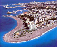 Rhodes Rhodes
Rhodes is the furthest south eastern island of Greece. it is a very popular, cosmopolitan island, where both Venetian and Turkish influence are apparent, giving it a special charm. Apart from the main harbour of Rhodes, where the magnificent statue of the Colossus once stood, you will find many picturesque, little coves, where you can swim in magical surroundings.
Mandraki - The main harbour of Rhodes. You cab tie on the N or the N end of the E quay. You will find the harbour can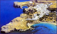 be fairly crowded and there is often four boats out from the quay. The harbour offers good shelter from prevailing winds. There is water and electricity available at the quay as well as fuel. All provisions can be found. be fairly crowded and there is often four boats out from the quay. The harbour offers good shelter from prevailing winds. There is water and electricity available at the quay as well as fuel. All provisions can be found. Lindos – You can moor where convenient in this large bay. The water is turquoise and offers an excellent area for a swim. Take the time to go ashore to visit the acropolis it is well worth the visit. 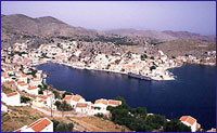 Symi Symi
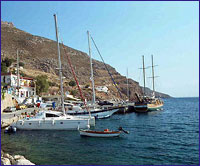
This rocky, mountainous island, north west of Rhodes, is one of the most beautiful of the Dodecanese. Here, mast of the inhabitants live off sponge diving. The main part is Gialos. Other interesting villages include Nimborios, Marthoundas, Pedi and Panormos. Enjoy swimming in the clear waters of Symi, but don't forget to taste the excellent wine, honey, almonds and olives produced here.
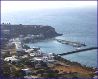
Datça
 Datca, from which the peninsula derives its name, is a coastal district that possesses a jetty offering shelter from the wind. The jetty is on a peninsula that stretches towards the E, four nautical miles to the N of Ince Boron, which is marked on the chart with a lighthouse. This peninsula divides two bays, one to the N and the other to the 5, whereas the one to the S is protected by a breakwater which is positioned in the sea in a SE direction. There is a half-salt, half-freshwater lake adjacent to the district’s SW shore. Datca, from which the peninsula derives its name, is a coastal district that possesses a jetty offering shelter from the wind. The jetty is on a peninsula that stretches towards the E, four nautical miles to the N of Ince Boron, which is marked on the chart with a lighthouse. This peninsula divides two bays, one to the N and the other to the 5, whereas the one to the S is protected by a breakwater which is positioned in the sea in a SE direction. There is a half-salt, half-freshwater lake adjacent to the district’s SW shore. Reference : "Paradise Preserved" by Ilhan Aksit
|