Aegina
The closet island as you depart from Kalamaki marina and is usually the first or last stop of your trip if you are sailing the Saronic Gulf. The Temple o Aphia is well worth a visit. You can either visit by taking the bus from the main harbor or moor in Agia Marina and take the caique. The temple is one of the best developed classical temple in Greece. Don’t forget to stock up on pistachios as they are produced on the island of Aegina and are probably the best in Greece.
· Main Harbor Aegina – A well sheltered harbor but when there are strong southerly winds it does have a bit of a swell. Mooring is stern-to or bow to the quay. A good place for provisioning, water and fuel.
· Perdika – Small bay on the SW of Aegina. It is a good shelter from normal winds the bay is open to the west but Nisis Moni does offer protection from westerly winds. Care must be taken if you decide to tie quay. Depths vary from 1,5M to 1,9M so some care must be taken. No fuel available, water can be arranged. The taverns on Perdika have excellent fresh fish.
· Ag. Marina – A large open bay located in the NE corner of the island. Mooring is in the bay . This area is not well sheltered but if the weather is calm it is a nice area to moor in
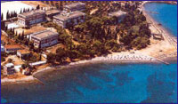
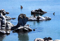
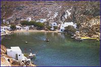
Hydra
Hydra is an island with many admirers, among the international community of writers, actors and artists in general. Perhaps because of its unique charm, or perhaps because of its rare combination of simplicity and sophistication. You can walk, under the shade of grapevines, on its narrow cobblestone streets, that lace around the old houses, following their wild climb, almost to the top of the steep hills. Or you can just rest, lying on a rock by the sea. No matter what, Hydra will charm you just the same. Hydra, with its historically - preserved architecture, its numerous churches, and its donkey transportation, is one of the most picturesque islands.
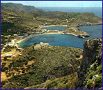
Hydra Main Harbor – If you want to tie in the main harbor I suggest you get in early, especially on the weekends as it is a favorite for the Greeks. Care must be taken when they are N-NW winds and you should opt for the N mole. Due to the harbor is overcrowded in the summer it is usually for yachts to be three out from the quay. Crossed anchors are a common event so don't be surprised. Water is available on the quay, as well as provisioning.
Mandraki – This bay is located ?? of mile E of Hydra. It is a nice bay for a swim There are taverns ashore. The bay is fairly sheltered except to northerly winds.
Petassi - There are several small coves in the area that can be used.
Ag. Nikolaos – This is a beautiful bay with nice surroundings and crystal clear water for a swim but can only be used in calm weather.
Nisis Dhokos – A barren island SW end of Hydra. The winds in the channel vary and usually die down. A safe anchorage which is well protected.
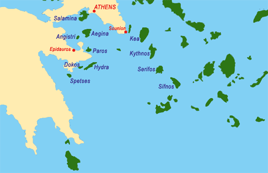
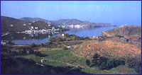
 Spetses
A wonderful island, only five miles away from the coast of Peloponese, a favoured location for international scientific seminars, Spetses, possesses a certain mystery of contradiction. Ideal for exploring, wind surfing, swimming, spear fishing, good food, dancing or relaxing away from everything. A marvellous choice for everyone and a surely unforgettable experience.
Spetses Old Harbor – You should anchor in the bay with line ashore. If you find room you can tie in the inner harbor. If there are strong NW winds it can become dangerous. There 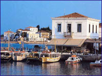 is fuel and water available at the quay provisions are available as well as several tavernas for eating out.
Spetses New Harbor – The harbor is reserved for caiques, water taxis and the ferries. If you try to tie here most likely you will be asked to leave.
Ormos Zoyioryia – This large bay located on the NW corner is very attractive and an ideal place for a swim. It offers good shelter except from N or NW winds. There is a taverna ashore.
 Paros
Paros
Paros, the third largest of Cyclades after Naxos and Andros has developed into an important center of tourism in recent years. Gently rolling hills surround the center and south-east of the island which is predominately agricultural and is occupied by endless vineyards, and lock within themselves the famous Parian marble. The coastline is indented, with numerous small inlets and two large bays, those of Naoussa in the north and Parikia in the west. Paros has been inhabited since very ancient times, and was one of the centers of the Cycladic civilization.
Parikia (or Paros), the island capital and port, stands on the site of an ancient city. There is a picturesque and ruinous Venetian castle and the courtyards of the houses of the town -all of them painted white- are full of pots of basil and hung with jasmine and honeysuckle. A broad paved avenue leads to the church of Ekantondapiliani or Katapoliani, one of the most important Byzantine monuments in the whole of Greece and a place that figures largely in legend. It is dedicated to the Dormition of our Lady, and on her feast day (15 August) there is a great celebration on the sea-front with fireworks and songs of the sea
Other interesting local events take place on the island during the summer. Statues found at various sites on Paros are on display in the National Archaeological Museum, Athens.
Naoussa, one of the prettiest villages in Cyclades, with white washed houses, narrow paved alleys, arches and tiny chapels can also offer a range of excellent beaches and attracts many visitors each summer.
 Among the beaches near Naoussa, special mention should be made of Kolibithres, where huge rocks eroded into strange shapes remind the visitors of sculptures embedded in the sand.
The chapels and monasteries of Paros are famed for their picturesqueness; among the most characteristic are the monastery of Zoodohos Pigi 'Longovarda' and that of Christ of the Forest (Hristos tou Dassous).
Marpissa is an attractive large village with a Venetian castle and beautiful churches. Among the best swimming beaches are Livadia, Krios, Agios Fokas, (at Parikia), Mikro Piperi and Megalo Piperi, Limnes, Kolimbithres (at Naoussa), Agii Anargiri, Langeri, Aliki, (with an interesting exhibition of traditional crafts), Santa Maria, Ambelas, Pisso Livadi, and Drios (on the eastern side).
Paros is an ideal destination for those in search of cosmopolitan bustle and for lovers of solitude alike. It has a full range of tourist amenities.
 Kea
Kea
The island of Kea belongs to the Cyclades. Its many quiet beaches and the rich historical tradition make it the perfect destination for long and short vacatios.
Korrisia, the port of the island, is built on the ruins of the ancient town Korissos and along with Ioulida, Karthaia and Piiesa, they are the four towns of the island.
This is the island, where the famous statue the 'Kouros of Kea' was found and is now in the Archeological Museum in Athens.
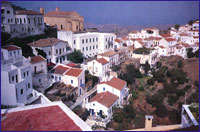 The capital of Kea, Ioulida, was built on the mounten, in order to be protected from pirates.
The settlement is one of the most well-preserved in the Cyclades and its' arcitectural personality, with the stone-paved paths, the neoclassic buildings, the churches and the red roofs make a wonderful scenery.
In the Archeological Museum one can see interesting exhibits of the Cycladic art and the Castle reveals one of the most amazing sunsets.
 Kythnos
The island of Kythnos, or, as the locals call it, Thermia, lies between Kea (Tzia) and Serifos, 54 nautical miles from Pireaus.
Administratively, Kythnos belongs to the Kea province of the Prefecture of Cyclades. It has an area of about 100 sq. km. (38 sq. miles) and a circumference of 36 miles. The terrain is rocky with Ai-Lias (336 m.) the tallest pick.
Although Kythnos is not far from Piraeus and Kea, one can find there unexpected peacefulness. Here, too, the terrain is mainly mountainous, but the harshness of the bare earth is relieved here and there by vines or fig-trees like brushstrokes on it, while pretty little bays form indentations in its coastline. There are steep cliffs on the 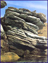 northern side of the island.
The small gulfs which keep the sea peaceful, the white houses, the streets and the old windmills, are some of the attractions of the island. Kythnos is close to Athens, so it is suitable even for weekends.
Beautiful beaches can be found at Meriha, Loutra (you can reach Loutra by bus from Meriha or Hora), Agios Stefanos (40' min. walk from Hora), Skylou, Kolona and Panagia Kanala. Other good beaches for swimming can be found at Episkopi and Flambouria bay (accessible only by boat).
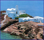
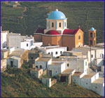
 Sifnos
Sifnos is one of the six islands that make up the Western Cyclades. It is wellknown both in Greece and abroad, for its unique and changeless traditional whitened buildings harmonising enchangly with the natural surroundings, for its remarkable cleanliness, for its countless churches and monasteries and its superb beaches.
The history of Sifnos began abot 3200B.C. and through the years it has been influenced by great civilizations, like the Minoan and the Mycenean civilization.
Apollonia, the capital of the island, spreads amphitheatrically over three hills.
1,5 kilometres north of Apollonia is picturesque Artemonas, with its windmills crowning the hill and a panoramic view.
 Kamares, the port of the island has a beautiful setting, humming with life in summer. It has a large beach and numerous ceramic workshops.
Platis Gialos is the most popular beach of the island and is the largest one in the Cyclades.The small villages of Vithi, Faros and Hersonisos with their little bays, are also worth seeing.
There are hotels, pensions, apartments, private rooms and camping sites almost all over the island. Nightlife on the island is also very good. Tavernas and restaurants with Greek and local specialities, bars and discos.
 Serifos
Between Kithnos and Sifnos, Serifos is 73 nautical miles from Piraeus. Bare, undulating hills interspersed with small, fertile valleys cover this picturesque island. The rocky coastline is deeply indented with a succession of coves and bays.
The curious rock formations resemble human figures which call to mind the myth of Danae, Perseus and Medusa, as if these prehistoric inhabitants of the island had been turned to stone.
The most interesting site of the island, the monastery of Taxiarhes is located on the main mountain, which looks like a castle. If you're looking for a quiet place, with wonderful beaches to spend your holidays, Serifos is the place.
According to mythology Perseas with his mother Danae, came to the island in a box that was thrown in the sea. Perseas grew up in the island and he was the one to kill the terrifying Medusa.
Ferries call at Livadi, the sheltered port on the eastern side of the island, where there is a long, horseshoe-shaped sandy beach.
Perched on the top of a steep hill, Hora or Serifos, the main town of the island, with its little cube-shaped houses and churches in the island style, with its Venetian castle above, looks like a fairy tale town.
The fortress-like monastery of the Archangels (moni Taxiarhon), near the village of Galani, which houses some fine wall-paintings and important books and manuscripts, is of special interest.
The village of Panagia (which takes its name - meaning 'Our Lady' - from the dedication of a fine 10th century church) commands a panoramic view of the whole island.
The greatest attraction of Serifos is its magnificent beaches (Mega Livadi, Koutalas,Agios Sostis, Psili Amos, Agios Ioannis, Sikamia).
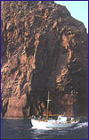
 Kithira
The island of Kithira lies opposite the eastern tip of the Peloponnese, Cape Malea. Its scenery Is unique - rugged and dramatic, while its architecture is a blend of traditional, Aegean and Venetian elements. Over the millennia, the winds from the surrounding seas have shaped its shores into steep rocky cliffs punctuated by deep bays.
Kithira has been known since antiquity as the island of Aphrodite.
At the start of the second millennium B.C. It was a Minoan colony and in 424 B.C. it came under the sway of Athens. Over the centuries it knew a succession of conquerors from the Romans to the Byzantines, Venetians and Turks, and it was frequently looted by Barbary pirates. The main town was completely destroyed in 1537 by the notorious Barbarossa. In 1717 in was rebuilt by the Venetians and in 1864 united with the Greek state.
Angistri
Angistri is the small island lying 4 miles to the west of Aigina and connected to it by a strip of shoal water (8-9 meters least depth through the channel near to Aigina). Angistri is hilly with the summit on the eastern side (296 metres/965ft). It is covered for the most part in pine and supports a small population. There are tavern and cafes at the harbour. Provisions available in Angistri village