 Gokova Gulf Gokova Gulf
Possessing several beautiful bays, the Gulf of Gokova begins at Hüseyin Burnu adjacent to Turgut Reis and ends at Iskandil Burnu at the end of Datça Peninsula. That is, you will be sailing along a recess which is 60 nautical miles long from W to E between these two points. The Greek island of Kos otherwise known as Istankoy Adasi is situated at the entrance of this gulf. In sailing out of Bodrum Harbor on your Blue Voyage, you may set a direct course for Knidos and Tekir Burnu, or else proceed along the bay-indented coastline of the Gulf of Gokova. Vessels setting out from Bodrum to visit Gokova navigate past Karaada, famous for its hot springs and known in ancient times as Arkanessos, then Fabuç Burnu, to arrive at Kargicik Koyu. Before reaching this point, you will see a small island called Kistak that you can maneuver past on either side, but care must be taken to avoid the small rocky islet to the N of the island. Yachts may anchor on its S side of Kargicik, which is a nice, large bay. Taking a swim in its crystal-clear water is a distinct pleasure. Before Kargicik Koyu is Orak Adasi, where there are two bays, one to the E and the other to the N. The best anchorages are along the NW side. Leaving here, you sail past Kara Burun to reach Alaksla Koyu, prior to which you will see Yildiz Adasi, whereby you should navigate your vessel close to the island and the mainland. It is possible to anchor off the SW point of the bay. After leaving Alakisla Koyu, you will cruise by Tekerek Limani, 11gm Limani and Kargili to finally arrive in Cokertme Koyu, which is the best anchorage around. This spot is surrounded by pine woods and olive groves and provides shelter from the prevailing winds. Inside the bay is the village of Cokertme, the W side of which is a decent anchorage point.  Departing Cokertme, you will arrive at Camalti Koyu, the jetty for Oren where you may visit the ruins of Keramos. Located 48 km. from Milas, this Carian city can be reached overland as well. The modern town of Oren is situated over the ancient city of Keramos. Though we don’t know exactly when it was founded, Keramos goes back to at least the 5th century B.C. as it was a member of the Delian Confederacy. Departing Cokertme, you will arrive at Camalti Koyu, the jetty for Oren where you may visit the ruins of Keramos. Located 48 km. from Milas, this Carian city can be reached overland as well. The modern town of Oren is situated over the ancient city of Keramos. Though we don’t know exactly when it was founded, Keramos goes back to at least the 5th century B.C. as it was a member of the Delian Confederacy.
Pulling out of Oren and proceeding 6.5 nautical miles past Kara Burun, you will sail into Akbük Limani. Situated at the foot of thickly wooded mountains. Akbük is a very decent harbor which offers shelter against W and NW winds. There is a cafe and a restaurant here and one may anchor on the jetty before the harbor or else W of it. From here one may proceed to Gokova Iskelesi, the extreme end of the Gulf of Gokova. Encircled by emerald green mountains, one never tires of the beauty of Gokova. There are two concrete jetties here and one may anchor in front of the bay. If you are planning to travel to Marmaris from here by car, you shall be able to gaze from the road 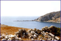 Knidos Knidos
Pulling out of Mersincik Limani and steering past Tekir Bükü, you will maneuver past lskandil Burnu to arrive in the small harbor of Knidos, which is the final bay along the Aegean seaboard. This was military harbor of Knidos, whereas the ancient geographer and historian Strabon from central Anatolia once wrote that 20 ships were able to moor here simultaneously. Warships once entered the harbor through a corridor to manuever past two round-shaped control towers at the narrowest spot. Please take note that the harbor on the N side of the isthmus is clogged with silt and with a draft of one meter is too shallow for even the smallest of boats. The actual harbor in use today is on the opposite side of the isthmus which is reached by navigating around Deveboynu Burnu. and its lighthouse, which can be seen as far as the entrance, The harbor entrance is 160 m. wide and one should approach the dock keeping clear of the ancient breakwaters. The one on the SW side is still in good condition, but the one in the NE side is submerged and can only be seen as a greenish-brown smudge under the water. Yachts can moor lines to the wooden jetties situated in front of the ancient city of Knidos. Draft in front of these jetties is down to 3.5 in., so you should be able to moor here without any trouble. In addition, you can easily drop anchor either in front of the theater inside the bay or else across from it. In addition to the ancient structures here, there is also a restaurant, an excavation bureau and storage facilities as well as a gendarmes station. The main harbor becomes unusable whenever severe gusts from the S and SE blow in. The road coming from Datça ends at the harbor. Moor your vessel in the main harbor of ancient Knidos and thoroughly enjoy the history and sea.
Mersincik
 If you are sailing in from the N side of the Gulf of Gökova, Mersincik Limani is the final anchorage point after Körmen. It is 1.5 nautical miles SE of Mersincik Adasi. The bay is ringed with high mountains with woods, whereas the village of Mersincik is situated in the S point. Sailing past the N or S of Mersincik Adalari, you will enter Mersincik Limani, which is exposed to the NE. There is an anchorage spot right behind the cape to the W at the entrance. The draft at the entrance is 15 in., which drops to 4 m. by the time you reach the end of the harbor. Although the draft in front of the small pebbled beach is 6-10 in., the bottom is of loose sand, rendering this spot inappropriate for anchoring. However, the NE and SW parts of the shore are more suitable for dropping anchor. From here, let’s sail for the famous ancient city of Knidos. If you are sailing in from the N side of the Gulf of Gökova, Mersincik Limani is the final anchorage point after Körmen. It is 1.5 nautical miles SE of Mersincik Adasi. The bay is ringed with high mountains with woods, whereas the village of Mersincik is situated in the S point. Sailing past the N or S of Mersincik Adalari, you will enter Mersincik Limani, which is exposed to the NE. There is an anchorage spot right behind the cape to the W at the entrance. The draft at the entrance is 15 in., which drops to 4 m. by the time you reach the end of the harbor. Although the draft in front of the small pebbled beach is 6-10 in., the bottom is of loose sand, rendering this spot inappropriate for anchoring. However, the NE and SW parts of the shore are more suitable for dropping anchor. From here, let’s sail for the famous ancient city of Knidos. 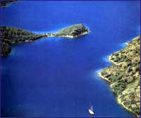 Seven Islands Seven Islands
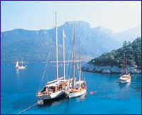
It is as though Mother Nature has spread some intricate lacework in these parts, with the scenery around Yedi Adalar enchanting enough for those on a Map of Yedi Adalar. ‘Blue Voyage’ to explore the many inland bays. After coming out of Tuzla Koyu, you can set a course for Yedi Adalar, passing Hirsiz Koyu and going beyond Teke Burnu and Teke Koyu.
We wanted to view this wide bay, known as ‘Yedi Adalar,’ as there are seven islands of various sizes, from the mainland. What we noticed was that the unbelievable beauty is as hidden from the mainland as it is from the sea. The panoramic collage of green woodland and deep blue water works its magic to take on the hue of turquoise. 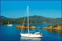 Tuzla Bay Tuzla Bay
Tuzla Koyu is 2.5 nautical miles E of Koyun Burnu, which is marked on the chart with a lighthouse. This bay is in the shape of a deep inlet that extends E. You need to pay heed to the small islet as yojnter the bay. The Karamuk Kayaliklari are situated at t e other point, and it is difficult to make out these shoals on the surface of the water. Small boats can drop anchor in the lake at the end of Tuzla Koyu and tie up on shore facing E. Though Tuzla Koyu is very calm and is closed off from winds, it does get an occasional gust in from the NE. Once entering, you can moor in any of several coves inside the bay. After tying up your vessel in the S quadrant of the bay, swimming in the crystal-clear water is a pleasure in itself. You cannot steer between the mainland and the small island in front of the bay, however, you can maneuver around either side of the island, which is in the middle.
There is the Tuz Gölü (Salt Lake) to the left of the 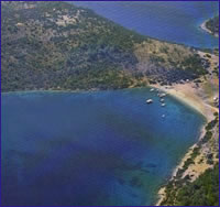 entrance to Tuzla Koyu, and it is because of Tuz Gölü that this place was named ‘Tuzla Koyu.’ Today, sea water mixes with that of Tuz Gölü rendering it unsuitable for extracting the sun-dried salt. The area which was scorched during the forest fires that raged through here four years ago can be seen in a naked and melancholy manner. The conflagration wiped out all the laurel trees in the bay, whereas the leaves of these trees were harvested and sold commercially, Styrax and pine trees are found at the very back of the bay. Although the right side of the bay is a blackened hulk, the left side was spared from the fire, which puts a smile on our face. The mud at the bottom of the bay is of a consistency that does not hold anchors. Moreover, vessels cannot enter and cannot drop anchor in the inner part of Tuzla Koyu, which is a natural bay. entrance to Tuzla Koyu, and it is because of Tuz Gölü that this place was named ‘Tuzla Koyu.’ Today, sea water mixes with that of Tuz Gölü rendering it unsuitable for extracting the sun-dried salt. The area which was scorched during the forest fires that raged through here four years ago can be seen in a naked and melancholy manner. The conflagration wiped out all the laurel trees in the bay, whereas the leaves of these trees were harvested and sold commercially, Styrax and pine trees are found at the very back of the bay. Although the right side of the bay is a blackened hulk, the left side was spared from the fire, which puts a smile on our face. The mud at the bottom of the bay is of a consistency that does not hold anchors. Moreover, vessels cannot enter and cannot drop anchor in the inner part of Tuzla Koyu, which is a natural bay. 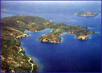 Kargili Bay Kargili Bay
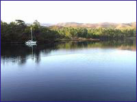
Kargili Koyu, which has a wide mouth, gradually narrows to a point where it seemingly buries itself into the mainland. Closed off to all winds, this bay, which is surrounded with pine, eucalyptus and styrax trees spread out like a broadcloth, is a great anchorage spot. There are two streams which flow into the bay. It is suitable to drop anchor anywhere in this bay, but in front of these streams, You can tie a mooring line around one of the pine trees up on shore.
 Ingiliz Limani ( English Harbour ) Ingiliz Limani ( English Harbour )
Is a magnificent anchorage place.Accrding to local tradition part of the British fleet concealed itself here during the World War I .
Sehir Islands
Seven nautical miles SW of Gokova Pier, at a spot near Çamli Limani are three islands known as Sehir Adalari. The larger of these, which are situated between Çapa Burnu and Domuz Burnu, is Saray Adasi or Cleopatra Island, as it is called by the locals. It is also shown on nautical charts as Sehir Adasi or Sedir Adasi. The other two islets are called Orta(Yuan) and Kucuk (Kale). There are remnants from the ancient city of Cedrai on the big island. It is said that the Egyptian Queen Cleopatra basked on the beach and to feel more at home, she had Marc Antony bring sand all the way from Egypt. While it is true that the sand here has an unusual consistency, it was not shipped in all the way from Egypt as the popular legend goes, but rather of a peculiar calcium carbonate formation not found anywhere else in the region.  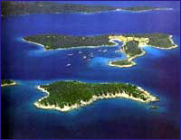
 Cökertme Cökertme
Çökertme, which is a bay situated in front of a village of the same name. Old maritime charts indicate this bay, which is situated between Kepce Burnu and Kara Burun, used to be called Fesliyen Koyu. Island pine woods and olive groves cover the low mountains and hills surrounding the bay. Positioned 7.5 nautical miles from Alakisla Koyu, one enters Çökertme Koyu by navigating past Kepce Burnu.
Due to a wide recess which has formed between the mountains, Çökertme Koyu offers shelter from all winds. However, the bay, which is exposed to the 5, receives an occasional big wave or two. In departing Çökertme Koyu, you can set a course for Çamalti Bükü via Kara Burun. 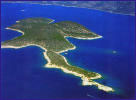 Orak Island Orak Island
One of the larger islands in the Gulf of Gökova is Orak Adasi, which lies in the approach to Kargicik Bükü. The name most probably comes from the fact that the end of the island resembles a sickle. Orak Adasi is located about five nautical miles E of Kara Ada and in front of Pabuc Burnu, whereas its W and N shores are spotless.
Also, a good place to drop anchor would be the bay located on the E side of the island, which is sheltered from N and W winds. There is a small islet situated in front of the bay. The bay can be entered by approaching from the N  of the island and navigated past this small islet. Rocks surround the entire island as well as the bay. You can drop anchor in 4-5 m. of water and tie a mooring line around one of the rocks lining the shore of this bay, which is a decent anchorage spot. There is a small inlet located next to this bay which is also suitable for dropping anchor. These small inlets offer you some privacy whereas you can take a refreshing dip in the sea whenever your heart desires. of the island and navigated past this small islet. Rocks surround the entire island as well as the bay. You can drop anchor in 4-5 m. of water and tie a mooring line around one of the rocks lining the shore of this bay, which is a decent anchorage spot. There is a small inlet located next to this bay which is also suitable for dropping anchor. These small inlets offer you some privacy whereas you can take a refreshing dip in the sea whenever your heart desires. Yildiz Adasi is situated in front of Alakisla Bükü, which is situated three nautical miles NE of Orak Adasi. The seabed at Alakisla Bükü doesn’t hold anchor. Although a harsh meltem blows through this bay, which is exposed to the 5, it offers shelter against N and W winds. 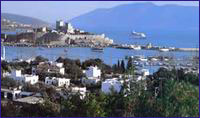 Bodrum Bodrum
Bodrum, the native homeland of the famous historian Herodotus, is one of Turkey’s most important tourism centers, which attracts attention by virtue of its natural beauty.
We know that the native inhabitants, namely the Lelegians and the Carians, lived in the hills above the Bodrum Peninsula. In fact, although there are very few remnants extant, it has been determined that a number of Lelegian cities such as Termera, Pedesa, Thangela, Syengela, Myndos and Telmissus existed above the peninsula. In the Iliad, Homer tells us that the Lelegians, who were under the command of Altes, as well as the Carians, under the command of Nartes fought on the side of the Trojans during the Trojan Wars of ca. 1200 B.C. 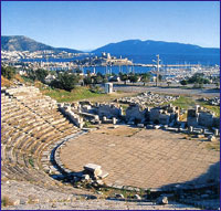 After the Turks entered Anatolia in 1071, they ater began establishing provinces in the regions they had settled. As a matter of fact, the Turks under command of Mentese Beytook over this region and the established the Mentese Province in 1274. This area was put under Ottoman rule once and for all during the reign of Sultan Suleyman the Magnificent After the Turks entered Anatolia in 1071, they ater began establishing provinces in the regions they had settled. As a matter of fact, the Turks under command of Mentese Beytook over this region and the established the Mentese Province in 1274. This area was put under Ottoman rule once and for all during the reign of Sultan Suleyman the Magnificent
As we mentioned at the beginning of this chapter, not much remains to this day of Halicarnassos as it is buried under the modern town of Bodrum. The theater on the hill belongs to the Mausolos period. Excavation and restoration work of the theater has been carried out, whereby 30 rows of seating in the lower section were brought to light. On the S slope of the theater, the upper section of which is heavily damaged, you can encounter rock tombs belonging to the Hellenistic and Roman Periods. Ancient sources reveal that 1) the Temple of Mars and the stoa of Apollo are under the road in front of the theater. 2) the Temples of Hermes and Aphrodite were situated on both sides of Kaplankale, across from the castle and 3) there was the palace of King Mausolos where the mosque is located, in the square in front of the castle. Today, the Myndos Gate, which was a portion of the wall that once surrounded the city, can be seen on the road to Gumbet The castle, which has become the symbol of modern day Bodrum, was built by the Knights of Rhodes in the year 1402. It measures 180 x 185 m. and its first battlements were erected by German architect Heinrich Schlegolholt. Later on, the castle was reinforced with the Italian, French, English, German Towers as well as the Snake Tower. There are a total of 249 coat-of-arms found throughout the castle walls. The Turks captured it in 1 523, whereas today, it serves as the Bodrum Museum of Underwater Archaeology. In the adjacent garden, you are bound to encounter numerous peacocks which seemingly stand guard over the treasures, not terribly unlike their Beefeater counterparts at the Tower in London. 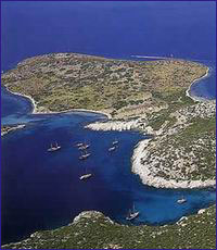 There are not many Turkish edifices in Bodrum. The famous Bodrum boats or gulet as they are known in Turkish were constructed during the Ottoman Period in a shipyard just beyond the yacht marina. Today, the manufacture of these fine wooden vessels continues in this area. There is the tomb of Kaptan-i Derya Kizilhisarli Mustafa Pasha and his son Cafer Pasha situated where this shipyard is located. There is also the mosque in the quay square that was built by Mustafa Pasha in 1720. The Pasha’s steward also had the Tepecik Mosque built. Erected in 1769, the Haci Molla Inn survives to this day. but not in its original fashion. There are not many Turkish edifices in Bodrum. The famous Bodrum boats or gulet as they are known in Turkish were constructed during the Ottoman Period in a shipyard just beyond the yacht marina. Today, the manufacture of these fine wooden vessels continues in this area. There is the tomb of Kaptan-i Derya Kizilhisarli Mustafa Pasha and his son Cafer Pasha situated where this shipyard is located. There is also the mosque in the quay square that was built by Mustafa Pasha in 1720. The Pasha’s steward also had the Tepecik Mosque built. Erected in 1769, the Haci Molla Inn survives to this day. but not in its original fashion.
Bodrum is one of the traditional points of embarkment for Blue Voyagers whereas its many bars, cafes, clubs and restaurants offer countless opportunities for fun until the crack of dawn. There are several sites of ruins around the Bodrum Peninsula. For example, you may visit the ancient city of Heracleia, which was established on top of a hill overlooking Bafa Gölü. There you will see the Temple of Athena, which was erected during the Hellenistic Age. Also, 12 km. outside of Milas, on the side of the road, you will encounter the Temple of Euromos Zeus with its 6 x 11 colonnade. It was erected during the Roman Age. Also, the Labranda Ruins, which are 13 km. outside Milas, are quite impressive as well. In addition, Iasos, which is situated in the village of Kiyikislacik is worth a visit. Reference : "Paradise Preserved" by Ilhan Aksit
|