 Bodrum Bodrum
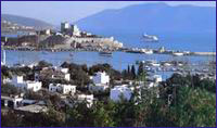
Bodrum, the native homeland of the famous historian Herodotus, is one of Turkey’s most important tourism centers, which attracts attention by virtue of its natural beauty.
We know that the native inhabitants, namely the Lelegians and the Carians, lived in the hills above the Bodrum Peninsula. In fact, although there are very few remnants extant, it has been determined that a number of Lelegian cities such as Termera, Pedesa, Thangela, Syengela, Myndos and Telmissus existed above the peninsula. In the Iliad, Homer tells us that the Lelegians, who were under the command of Altes, as well as the Carians, under the command of Nartes fought on the side of the Trojans during the Trojan Wars of ca. 1200 B.C. 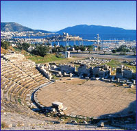 After the Turks entered Anatolia in 1071, they ater began establishing provinces in the regions they had settled. As a matter of fact, the Turks under command of Mentese Beytook over this region and the established the Mentese Province in 1274. This area was put under Ottoman rule once and for all during the reign of Sultan Suleyman the Magnificent After the Turks entered Anatolia in 1071, they ater began establishing provinces in the regions they had settled. As a matter of fact, the Turks under command of Mentese Beytook over this region and the established the Mentese Province in 1274. This area was put under Ottoman rule once and for all during the reign of Sultan Suleyman the Magnificent
As we mentioned at the beginning of this chapter, not much remains to this day of Halicarnassos as it is buried under the modern town of Bodrum. The theater on the hill belongs to the Mausolos period. Excavation and restoration work of the theater has been carried out, whereby 30 rows of seating in the lower section were brought to light. On the S slope of the theater, the upper section of which is heavily damaged, you can encounter rock tombs belonging to the Hellenistic and Roman Periods. Ancient sources reveal that 1) the Temple of Mars and the stoa of Apollo are under the road in front of the theater. 2) the Temples of Hermes and Aphrodite were situated on both sides of Kaplankale, across from the castle and 3) there was the palace of King Mausolos where the mosque is located, in the square in front of the castle. Today, the Myndos Gate, which was a portion of the wall that once surrounded the city, can be seen on the road to Gumbet The castle, which has become the symbol of modern day Bodrum, was built by the Knights of Rhodes in the year 1402. It measures 180 x 185 m. and its first battlements were erected by German architect Heinrich Schlegolholt. Later on, the castle was reinforced with the Italian, French, English, German Towers as well as the Snake Tower. There are a total of 249 coat-of-arms found throughout the castle walls. The Turks captured it in 1 523, whereas today, it serves as the Bodrum Museum of Underwater Archaeology. In the adjacent garden, you are bound to encounter numerous peacocks which seemingly stand guard over the treasures, not terribly unlike their Beefeater counterparts at the Tower in London. 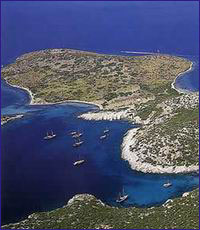 There are not many Turkish edifices in Bodrum. The famous Bodrum boats or gulet as they are known in Turkish were constructed during the Ottoman Period in a shipyard just beyond the yacht marina. Today, the manufacture of these fine wooden vessels continues in this area. There is the tomb of Kaptan-i Derya Kizilhisarli Mustafa Pasha and his son Cafer Pasha situated where this shipyard is located. There is also the mosque in the quay square that was built by Mustafa Pasha in 1720. The Pasha’s steward also had the Tepecik Mosque built. Erected in 1769, the Haci Molla Inn survives to this day. but not in its original fashion. There are not many Turkish edifices in Bodrum. The famous Bodrum boats or gulet as they are known in Turkish were constructed during the Ottoman Period in a shipyard just beyond the yacht marina. Today, the manufacture of these fine wooden vessels continues in this area. There is the tomb of Kaptan-i Derya Kizilhisarli Mustafa Pasha and his son Cafer Pasha situated where this shipyard is located. There is also the mosque in the quay square that was built by Mustafa Pasha in 1720. The Pasha’s steward also had the Tepecik Mosque built. Erected in 1769, the Haci Molla Inn survives to this day. but not in its original fashion.
Bodrum is one of the traditional points of embarkment for Blue Voyagers whereas its many bars, cafes, clubs and restaurants offer countless opportunities for fun until the crack of dawn. There are several sites of ruins around the Bodrum Peninsula. For example, you may visit the ancient city of Heracleia, which was established on top of a hill overlooking Bafa Gölü. There you will see the Temple of Athena, which was erected during the Hellenistic Age. Also, 12 km. outside of Milas, on the side of the road, you will encounter the Temple of Euromos Zeus with its 6 x 11 colonnade. It was erected during the Roman Age. Also, the Labranda Ruins, which are 13 km. outside Milas, are quite impressive as well. In addition, Iasos, which is situated in the village of Kiyikislacik is worth a visit. Orak Island
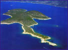 One of the larger islands in the Gulf of Gökova is Orak Adasi, which lies in the approach to Kargicik Bükü. The name most probably comes from the fact that the end of the island resembles a sickle. Orak Adasi is located about five nautical miles E of Kara Ada and in front of Pabuc Burnu, whereas its W and N shores are spotless. One of the larger islands in the Gulf of Gökova is Orak Adasi, which lies in the approach to Kargicik Bükü. The name most probably comes from the fact that the end of the island resembles a sickle. Orak Adasi is located about five nautical miles E of Kara Ada and in front of Pabuc Burnu, whereas its W and N shores are spotless. Also, a good place to drop anchor would be the bay located on the E side of the island, which is sheltered from N and W winds. There is a small islet situated in front of the bay. The bay can be entered by approaching from the N of the island and navigated past this small islet. Rocks surround the entire island as well as the bay. You can drop anchor in 4-5 m. of water and tie a mooring line around one of the rocks lining the shore of this bay, which is a decent anchorage spot. There is a small inlet located next to this bay which is also suitable for dropping anchor. These small inlets offer you some privacy whereas you can take a refreshing dip in the sea whenever your heart desires. Yildiz Adasi is situated in front of Alakisla Bükü, which is situated three nautical miles NE of Orak Adasi. The seabed at Alakisla Bükü doesn’t hold anchor. Although a harsh meltem blows through this bay, which is exposed to the 5, it offers shelter against N and W winds. 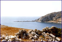 Knidos Knidos
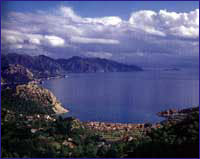
Pulling out of Mersincik Limani and steering past Tekir Bükü, you will maneuver past lskandil Burnu to arrive in the small harbor of Knidos, which is the final bay along the Aegean seaboard. This was military harbor of Knidos, whereas the ancient geographer and historian Strabon from central Anatolia once wrote that 20 ships were able to moor here simultaneously. Warships once entered the harbor through a corridor to manuever past two round-shaped control towers at the narrowest spot. Please take note that the harbor on the N side of the isthmus is clogged with silt and with a draft of one meter is too shallow for even the smallest of boats. The actual harbor in use today is on the opposite side of the isthmus which is reached by navigating around Deveboynu Burnu. and its lighthouse, which can be seen as far as the entrance, The harbor entrance is 160 m. wide and one should approach the dock keeping clear of the ancient breakwaters. The one on the SW side is still in good condition, but the one in the NE side is submerged and can only be seen as a greenish-brown smudge under the water. Yachts can moor lines to the wooden jetties situated in front of the ancient city of Knidos. Draft in front of these jetties is down to 3.5 in., so you should be able to moor here without any trouble. In addition, you can easily drop anchor either in front of the theater inside the bay or else across from it. In addition to the ancient structures here, there is also a restaurant, an excavation bureau and storage facilities as well as a gendarmes station. The main harbor becomes unusable whenever severe gusts from the S and SE blow in. The road coming from Datça ends at the harbor. Moor your vessel in the main harbor of ancient Knidos and thoroughly enjoy the history and sea.
 Datça Datça
Datca, from which the peninsula derives its name, is a coastal district that possesses a jetty offering shelter from the wind. The jetty is on a peninsula that stretches towards the E, four nautical miles to the N of Ince Boron, which is marked on the chart with a lighthouse. This peninsula divides two bays, one to the N and the other to the 5, whereas the one to the S is protected by a breakwater which is positioned in the sea in a SE 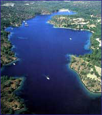 direction. There is a half-salt, half-freshwater lake adjacent to the district’s SW shore. direction. There is a half-salt, half-freshwater lake adjacent to the district’s SW shore.
Bencik
Bencik Koyu is a bay possessing extraordinary beauty. it extends inland up to 1.5 nautical miles through Bencik Koyu with its serrated rocks resembling human teeth. Bencik. which is the narrowest spot on Datça Peninsula, divides the Marmaris and Datça districts from each other. The inner reachs of the fjord are shallow and marshy, whereas its other parts are clean and sparkling blue. 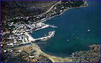 Bozburun Bozburun
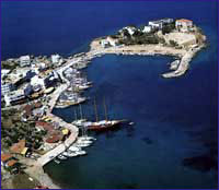
As Bozburun Harbor was established right at the foot of a rocky mountain, it is sealed off from all prevailing winds. Bozburun, which is the nearest inhabited place to Rhodes and Simi Island is famous for its boat construction. There are 25 shipyards here that are involved in the business of constructing wooden vessels.
The historical artifacts found on the islands situated in front of Bozburun imply that it was inhabited during ancient times. In the NE quadrant of Bozburun, there lies the ancient city of Larymna, which the local people call the Castle. The city’s acropolis is found on a hill called Asartepe. The old city’s necropolis is located on the slope of the hill, which can be reached by climbing up from the vicinity of the Bozburun Pier. Here, you can encounter ruins of a fortification wall and its rectangular-shaped battlements. The ancient city of Tymnos, which until recently was thought to be in Bozburun, is actually further E in Sögüt One can find a post office, gendarmes station and village health clinic in Bozburun where you can also dine in the restaurants and purchase provisions in the markets. Bozukkale
 Bozukkale Harbor maintained its importance throughout the Byzantine Period as a Byzantine naval base and armory, whereas warship maintenance was carried out in this shipyard. Bozukkale Harbor maintained its importance throughout the Byzantine Period as a Byzantine naval base and armory, whereas warship maintenance was carried out in this shipyard. After anchoring in this historical bay, let’s climb up to see the castle situated at the end of the cape. Measuring 27.4 m. wide by 320 m. long, and surrounded by fortification walls 2.44 in. in thickness, this long, narrow castle was erected to protect the bay. There were once nine square-shaped ramparts along protective walls made from straight cut stones. However of the original nine, only a single promontory rampart in the N can be seen today. There are round towers situated at the two ends of the castle. Immediately in front of these towers are cisterns which were carved partly from the rock. Four of the five gates of the fortification wall are situated in the section facing N. The ancient city of Loryma is situated on the hill to the B of the bay. If you have the time and are interested in history, it will take you about an hour to hike up the hill, whereby you can wander around this ancient city. You will find it is a nice way to regain your landlubber legs after spending so much time at sea 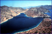 Serce Limani Serce Limani
Ancient mariners knew that Serçe Limani was a sheltered harbor that they often took refuge during stormy weather. Here there are a total of six shipwrecks found in the vicinity; four inside the bay and two outside the bay. One of these occurred in the year 1025. The captain piloting a Fatimid-flagged cargo vessel that had set out on its fateful journey from the Syrian coast bound for Constantinople. In addition to other cargo, its manifest indicated she was loaded with up to three tons of processed and raw glass that was to be processed in a small workshop located on the shores of the Bosphorus.
Weeks had gone by since the vessel had departed Syrian waters, and it sailed all the way to Bozukkale without any difficulty. After porting here for a while, she set sail, but it wasn’t long before she was caught in a terrible storm. To escape the maelstrom, the ships captain tried to duck into Serçe Limani, but unfortunately his vessel struck the rocks and was
damaged. He did manage to navigate her into the harbor, but she began taking on water and it wasn’t long before the vessel sank to the bottom of the sea with its precious load. It was almost a full millennium before this 16 m. vessel was brought back to the surface, when Prof. George Bass, along with a team of Turkish and American underwater archaeologists, accomplished this task in 1979. Today, the ship along with all its contents is on display at the Bodrum Museum of Underwater Archaeology.
The ancient town of Kasara is located above Serce Limani, which most likely was the harbor of this ancient town. Kasara means “the Big Village of the Mother Goddess.” Other than a few wall remnants, nothing else remains of this ancient town. 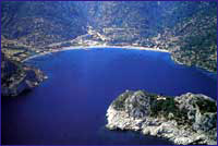 Ciftlik Ciftlik
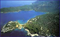
Çiftlik Limani is located one nautical mile NE of Ince Burun, whereas Çiftlik Adasi is situated in front of this beautiful bay with its wide beach. This island facilitates relative protection for the bay from prevailing NW and SE winds. There is a holiday village at the B end of this round bay, whereas hotels and restaurants are found in the middle. The concrete pier in front of the holiday village belongs to the hotel. There are steel piers in front of the restaurants in the bay. You can secure your yacht along one of the piers in this beautiful bay and dine in one of the restaurants here.
Kadirga Burnu
 Kadirga Burnu, where a lighthouse and a cottage for the lighthouse operators are situated. Kadirga Limani is right behind the cape. This is also known as ‘Çayagiz Koyu.’ There are submerged rocks in front of Kadirga Limani’s other cape. There are two inlets in the wide bay between the two capes. You can pitch your anchor overboard in the S inlet to a depth of 6 m. and tie your yacht to the shore. This location is closed off from all winds and exposed to the NW and B. You can navigate between the mainland and an island situated in front of the N cape of the bay. This is an ideal spot for those who like to swim. Kadirga Burnu, where a lighthouse and a cottage for the lighthouse operators are situated. Kadirga Limani is right behind the cape. This is also known as ‘Çayagiz Koyu.’ There are submerged rocks in front of Kadirga Limani’s other cape. There are two inlets in the wide bay between the two capes. You can pitch your anchor overboard in the S inlet to a depth of 6 m. and tie your yacht to the shore. This location is closed off from all winds and exposed to the NW and B. You can navigate between the mainland and an island situated in front of the N cape of the bay. This is an ideal spot for those who like to swim. 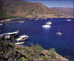 Kumlu Bükü Kumlu Bükü
Kumlu Bükü is a bay comprised mostly of sandy beach, hence the name ‘Kumlu Bükü.’ This beautiful wide bay, which is surrounded by tree covered mountains is one of the few bays with a freshwater spring. However, the bay is exposed to the N, and is affected by reverse winds. Winds blowing from the SE stir up rough waves in the bay. Nevertheless, this is one of the most ideal bays to drop anchor whenever there aren’t any strong winds gusting. Several mooring spots are found in Kumlu Bükü, which is very close to Marmaris. For instance, there is a small cove at the SE point of the bay that is striking for its crystal clear water. Shaded by pine trees, this cove is convenient for mooring in that you can drop anchor in 4 - 5 m. of water and tie a line to shore. Here, you will find the freshwater spring here as well as there are a few motels and restaurants located in the bay. One can take advantage of their services by mooring up alongside the piers. Daily excursion tour boats stop here for meal breaks, whereas sunseekers can catch some rays on the wide beach and take a dip in the sea to cool off.
The ruins of an ancient city called Amos are situated on top of Kumlu Bükü’s N cape. You can trek up the hill to check out these ruins from the point where the beach ends. Here, you will see a fortification wall measuring 1.83 m. thick and 3-3.5 m. high. The N side of this wall, which was constructed in the Cyclopean style, was reinforced with numerous ramparts. You can see that its gate was on this side. This wall along with all the other edifices in Amos date to the Hellenistic Period. Turunc Bükü
 The closest bay to Marmaris is that of Turunc Bükü, situated at a distance of two nautical miles outside Kumlu Bükü. Because of the cape situated in front, Turunc Bükü is regarded as a safe haven from prevailing winds. One can navigate into the bay by sailing between the island of Kargatasi and the mainland. There is a reef off the shore of the mainland, about half a nautical mile NW of this island. The closest bay to Marmaris is that of Turunc Bükü, situated at a distance of two nautical miles outside Kumlu Bükü. Because of the cape situated in front, Turunc Bükü is regarded as a safe haven from prevailing winds. One can navigate into the bay by sailing between the island of Kargatasi and the mainland. There is a reef off the shore of the mainland, about half a nautical mile NW of this island. 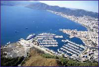 Marmaris Marmaris
As this quaint district, which is surrounded by green pine forests, was established directly over the ancient city of Phychos we do not have much information about the ancient site. However, from what we gather from a certain inscription, Phychos existed during the time of Alexander the Great, whereby the acropolis of this city was established one kilometer N of Marmaris on a low hill called Asartepe. Though it wasn’t long ago when there were visible remains of the ancient fortification wall, which was erected in the Classic and Hellenistic Periods, nothing can be seen of it today. After the death of Alexander, the Marmaris region was annexed to the Pergamon Kingdom, then it was captured by the Romans, Byzantines, the Mentese Beylik and then the Ottomans, respectively.
Among the few historical buildings found in Marmaris today, are a castle, which was built in 1557 and recently restored, a mosque in Kemeralti District, which was built by Mengelizade Ibrahim Aga in 1789 as well as a caravanserai which was constructed in 1545. This stone inn with brick vaults was erected on the road to Mugla during the reign of Süleyman the Magnificent in the military campaign against Rhodes. Located near the old junior high school is the Degirmen Brook Bridge, which was also erected during the time of Süleyman the Magnificent. 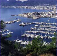 If you have the time, we recommend that you check out Sedir Adasi, as well as Karacasögüt, where you can see ancient theaters, temples and fortification walls. As you come out the bay, your boat will manuever past Keci Adasi and Yildiz Adasi, otherwise known as Nimara to call on Alkaya Cave. Then you will sail out to Kumlubük where to take a break of a couple of hours for lunch and an afternoon swim in the sea. Straight up from the pier are the Amos Ruins, which are situated on Asartepe. If you have the time, we recommend that you check out Sedir Adasi, as well as Karacasögüt, where you can see ancient theaters, temples and fortification walls. As you come out the bay, your boat will manuever past Keci Adasi and Yildiz Adasi, otherwise known as Nimara to call on Alkaya Cave. Then you will sail out to Kumlubük where to take a break of a couple of hours for lunch and an afternoon swim in the sea. Straight up from the pier are the Amos Ruins, which are situated on Asartepe.
With its styrax forest in the middle of the city, excursion trips taken with motorboats and its natural beauty, Marmaris is an ideal spot for rest and relaxation. In addition, the town, which is complimented with wonderful nearby bays such as Sedir Adasi, Karacasögüt, Mersincik, Hisarönü, is a paradise on earth. Reference : "Paradise Preserved" by Ilhan Aksit
|